Korbak geodata
Korbak (East Java) is a seat of a fourth-order administrative division; located in Indonesia in Asia/Jakarta (GMT+7) time zone. In our database, there are 407 cities with bigger population. Compared to other cities in Indonesia, 73.1% of cities are located further ↓South; 65.7% of cities are located further ←West and 67.4% of cities have higher elevation than Korbak. Note1


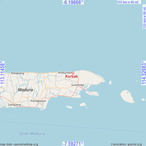
Korbak GPS coordinates[2]
6° 53' 42.72" South, 113° 49' 3.72" East
| Map corner | latitude | longitude |
|---|---|---|
| Upper-left | -6.19666°, | 113.11458° |
| Center: | -6.8952°, | 113.8177° |
| Lower-right: | -7.59271°, | 114.52083° |
| Map W x H: | 155.2×155.2 km | = 96.4×96.4mi |
| max Lat: | 5.88969° ⇑26.9% North |
| Korbak: | -6.8952° |
| min Lat: | ⇓73.1% South -10.934° |
| min Long | Korbak | max Long |
| 95.1345° | 113.8177° | 140.9419° |
| W 65.7%⇐ | ⇒34.3% E |
Elevation
Elevation of Korbak is 37 m = 121 ft, and this is 192.7 m = 632 ft below average elevation for this country.
| Max E: |
3185 m = 10449 ft | 67.4% |
| Avg. | 229.7 m = 754 ft | |
| Korbak | 37 m = 121 ft | |
Min E: |
-1 m = -3 ft | 32.6% |
See also: Indonesia elevation on elevation.city.
Geographical zone
Korbak is located in South Torrid zone (between Equator and Tropic of Capricorn). Distance of Equator is 766.7 km =476.4 mi to North.| Distance of | km | miles | from Korbak |
|---|---|---|---|
| Equator | 766.7 | 476.4 | to North |
| Tropic Capricorn | 1839.2 | 1142.8 | to South |
| Antarctic Circle | 6634.5 | 4122.5 | to South |
| South Pole | 9240.4 | 5741.7 | to South |


Nearby cities:
15 places around Korbak: (largest is in red/bold)
• Ares Tengah
4.3 km =2.7 mi,  276°
276°
• Bata Tengah
4.6 km =2.9 mi,  255°
255°
• Betangan
1.6 km =1 mi,  272°
272°
• Daja
2.7 km =1.7 mi,  190°
190°
• Dasuk
0.8 km =0.5 mi,  210°
210°
• Gunong
5.5 km =3.4 mi,  226°
226°
• Jungjungan
4.9 km =3 mi,  152°
152°
• Kaceng
3.2 km =2 mi, 230°
• Karangpocok
4.4 km =2.7 mi,  130°
130°
• Kombang
2.5 km =1.6 mi,  98°
98°
• Laok
5.1 km =3.2 mi,  200°
200°
• Lebak
3.7 km =2.3 mi,  285°
285°
• Nyapar
1.9 km =1.2 mi, 126°
• Tajan
3 km =1.9 mi, 264°
• Tengah
4.6 km =2.9 mi,  217°
217°
Sources, notices
• [Note1] Compared only with cities in Indonesia existing in our database
• [Src1] Map data: © OpenStreetMap contributors (CC-BY-SA)
• [Src2] Other city data from geonames.org with taken over terms of usage.
• [Src3] Geographical zone / Annual Mean Temperature by Robert A. Rohde @ Wikipedia
