Jungjungan geodata
Jungjungan (East Java) is a seat of a fourth-order administrative division; located in Indonesia in Asia/Jakarta (GMT+7) time zone. In our database, there are 407 cities with bigger population. Compared to other cities in Indonesia, 70.5% of cities are located further ↓South; 66% of cities are located further ←West and 56.7% of cities have lower elevation than Jungjungan. Note1


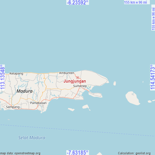
Jungjungan GPS coordinates[2]
6° 56' 3.84" South, 113° 50' 18.96" East
| Map corner | latitude | longitude |
|---|---|---|
| Upper-left | -6.23592°, | 113.13548° |
| Center: | -6.9344°, | 113.8386° |
| Lower-right: | -7.63185°, | 114.54173° |
| Map W x H: | 155.2×155.2 km | = 96.4×96.4mi |
| max Lat: | 5.88969° ⇑29.5% North |
| Jungjungan: | -6.9344° |
| min Lat: | ⇓70.5% South -10.934° |
| min Long | Jungjungan | max Long |
| 95.1345° | 113.8386° | 140.9419° |
| W 66%⇐ | ⇒34% E |
Elevation
Elevation of Jungjungan is 135 m = 443 ft, and this is 94.7 m = 311 ft below average elevation for this country.
| Max E: |
3185 m = 10449 ft | 43.3% |
| Avg. | 229.7 m = 754 ft | |
| Jungjungan | 135 m = 443 ft | |
Min E: |
-1 m = -3 ft | 56.7% |
See also: Indonesia elevation on elevation.city.
Geographical zone
Jungjungan is located in South Torrid zone (between Equator and Tropic of Capricorn). Distance of Equator is 771 km =479.1 mi to North.| Distance of | km | miles | from Jungjungan |
|---|---|---|---|
| Equator | 771 | 479.1 | to North |
| Tropic Capricorn | 1834.9 | 1140.2 | to South |
| Antarctic Circle | 6630.1 | 4119.8 | to South |
| South Pole | 9236 | 5739 | to South |


Nearby cities:
15 places around Jungjungan: (largest is in red/bold)
• Bungereng
4.3 km =2.7 mi,  45°
45°
• Cangkreng
4.1 km =2.5 mi,  172°
172°
• Daja
3.3 km =2.1 mi,  301°
301°
• Daja
4.8 km =3 mi,  248°
248°
• Dasuk
4.6 km =2.9 mi,  323°
323°
• Giring Barat
4.8 km =3 mi,  137°
137°
• Gununglajang
1.5 km =0.9 mi,  204°
204°
• Karangpocok
1.8 km =1.1 mi,  34°
34°
• Kleker
3.9 km =2.4 mi, 204°
• Kombang
4 km =2.5 mi,  2°
2°
• Korbak
4.9 km =3 mi,  332°
332°
• Laok
4.1 km =2.5 mi,  264°
264°
• Manding
4.2 km =2.6 mi,  119°
119°
• Nyapar
3.3 km =2.1 mi,  346°
346°
• Oro
4.5 km =2.8 mi,  182°
182°
Sources, notices
• [Note1] Compared only with cities in Indonesia existing in our database
• [Src1] Map data: © OpenStreetMap contributors (CC-BY-SA)
• [Src2] Other city data from geonames.org with taken over terms of usage.
• [Src3] Geographical zone / Annual Mean Temperature by Robert A. Rohde @ Wikipedia
