Kampungtengah geodata
Kampungtengah (East Nusa Tenggara) is a seat of a fourth-order administrative division; located in Indonesia in Asia/Makassar (GMT+8) time zone. In our database, there are 407 cities with bigger population. Compared to other cities in Indonesia, 96.4% of cities are located further ↑North; 94.7% of cities are located further ←West and 61.7% of cities have lower elevation than Kampungtengah. Note1


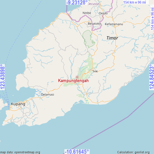
Kampungtengah GPS coordinates[2]
9° 55' 28.56" South, 124° 8' 31.56" East
| Map corner | latitude | longitude |
|---|---|---|
| Upper-left | -9.23128°, | 123.43898° |
| Center: | -9.9246°, | 124.1421° |
| Lower-right: | -10.61645°, | 124.84523° |
| Map W x H: | 154×154 km | = 95.7×95.7mi |
| max Lat: | 5.88969° ⇑96.4% North |
| Kampungtengah: | -9.9246° |
| min Lat: | ⇓3.6% South -10.934° |
| min Long | Kampungtengah | max Long |
| 95.1345° | 124.1421° | 140.9419° |
| W 94.7%⇐ | ⇒5.3% E |
Elevation
Elevation of Kampungtengah is 182 m = 597 ft, and this is 47.7 m = 156 ft below average elevation for this country.
| Max E: |
3185 m = 10449 ft | 38.3% |
| Avg. | 229.7 m = 754 ft | |
| Kampungtengah | 182 m = 597 ft | |
Min E: |
-1 m = -3 ft | 61.7% |
See also: Indonesia elevation on elevation.city.
Geographical zone
Kampungtengah is located in South Torrid zone (between Equator and Tropic of Capricorn). Distance of Equator is 1103.5 km =685.7 mi to North.| Distance of | km | miles | from Kampungtengah |
|---|---|---|---|
| Equator | 1103.5 | 685.7 | to North |
| Tropic Capricorn | 1502.4 | 933.5 | to South |
| Antarctic Circle | 6297.7 | 3913.2 | to South |
| South Pole | 8903.5 | 5532.4 | to South |


Nearby cities:
15 places around Kampungtengah: (largest is in red/bold)
• Bokong Timur
10.4 km =6.5 mi,  238°
238°
• Hane
8.9 km =5.5 mi,  82°
82°
• Koa
5.7 km =3.5 mi,  262°
262°
• Kuafeu
3.8 km =2.4 mi,  208°
208°
• Kuatnana
9.6 km =6 mi,  69°
69°
• Neofbaun
12.9 km =8 mi,  51°
51°
• Nunbaki
8.9 km =5.5 mi,  17°
17°
• Oebai
8 km =5 mi,  144°
144°
• Oehumusu
6.4 km =4 mi,  105°
105°
• Siso
10.4 km =6.5 mi,  55°
55°
• Taekas
3.5 km =2.2 mi, 107°
• Takari
11.7 km =7.3 mi, 242°
• Tubuhue
12.1 km =7.5 mi, 68°
• Tubunaen
6 km =3.7 mi,  183°
183°
• Tubunain
6.9 km =4.3 mi,  202°
202°
Sources, notices
• [Note1] Compared only with cities in Indonesia existing in our database
• [Src1] Map data: © OpenStreetMap contributors (CC-BY-SA)
• [Src2] Other city data from geonames.org with taken over terms of usage.
• [Src3] Geographical zone / Annual Mean Temperature by Robert A. Rohde @ Wikipedia
