Tubunaen geodata
Tubunaen (East Nusa Tenggara) is a seat of a fourth-order administrative division; located in Indonesia in Asia/Makassar (GMT+8) time zone. In our database, there are 407 cities with bigger population. Compared to other cities in Indonesia, 96.7% of cities are located further ↑North; 94.7% of cities are located further ←West and 50.6% of cities have lower elevation than Tubunaen. Note1


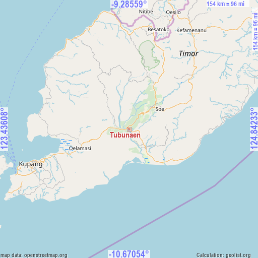
Tubunaen GPS coordinates[2]
9° 58' 43.68" South, 124° 8' 21.12" East
| Map corner | latitude | longitude |
|---|---|---|
| Upper-left | -9.28559°, | 123.43608° |
| Center: | -9.9788°, | 124.1392° |
| Lower-right: | -10.67054°, | 124.84233° |
| Map W x H: | 154×154 km | = 95.7×95.7mi |
| max Lat: | 5.88969° ⇑96.7% North |
| Tubunaen: | -9.9788° |
| min Lat: | ⇓3.3% South -10.934° |
| min Long | Tubunaen | max Long |
| 95.1345° | 124.1392° | 140.9419° |
| W 94.7%⇐ | ⇒5.3% E |
Elevation
Elevation of Tubunaen is 104 m = 341 ft, and this is 125.7 m = 412 ft below average elevation for this country.
| Max E: |
3185 m = 10449 ft | 49.4% |
| Avg. | 229.7 m = 754 ft | |
| Tubunaen | 104 m = 341 ft | |
Min E: |
-1 m = -3 ft | 50.6% |
See also: Indonesia elevation on elevation.city.
Geographical zone
Tubunaen is located in South Torrid zone (between Equator and Tropic of Capricorn). Distance of Equator is 1109.5 km =689.4 mi to North.| Distance of | km | miles | from Tubunaen |
|---|---|---|---|
| Equator | 1109.5 | 689.4 | to North |
| Tropic Capricorn | 1496.4 | 929.8 | to South |
| Antarctic Circle | 6291.6 | 3909.4 | to South |
| South Pole | 8897.5 | 5528.6 | to South |


Nearby cities:
15 places around Tubunaen: (largest is in red/bold)
• Aeka
12.3 km =7.6 mi,  168°
168°
• Bokong Timur
8.6 km =5.3 mi,  274°
274°
• Hane
11.6 km =7.2 mi,  51°
51°
• Kampungtengah
6 km =3.7 mi,  3°
3°
• Koa
7.5 km =4.7 mi,  314°
314°
• Kuafeu
3.1 km =1.9 mi,  331°
331°
• Kuatnana
13.3 km =8.3 mi,  44°
44°
• Oebai
5 km =3.1 mi,  95°
95°
• Oehaunu
8.7 km =5.4 mi,  186°
186°
• Oehumusu
7.8 km =4.8 mi,  56°
56°
• Oemofa
12.4 km =7.7 mi, 192°
• Oetaman
8.7 km =5.4 mi,  148°
148°
• Taekas
6.2 km =3.9 mi, 36°
• Takari
10.1 km =6.3 mi, 273°
• Tubunain
2.4 km =1.5 mi,  262°
262°
Sources, notices
• [Note1] Compared only with cities in Indonesia existing in our database
• [Src1] Map data: © OpenStreetMap contributors (CC-BY-SA)
• [Src2] Other city data from geonames.org with taken over terms of usage.
• [Src3] Geographical zone / Annual Mean Temperature by Robert A. Rohde @ Wikipedia
