Oebai geodata
Oebai (East Nusa Tenggara) is a seat of a fourth-order administrative division; located in Indonesia in Asia/Makassar (GMT+8) time zone. In our database, there are 407 cities with bigger population. Compared to other cities in Indonesia, 96.8% of cities are located further ↑North; 94.8% of cities are located further ←West and 59.4% of cities have lower elevation than Oebai. Note1


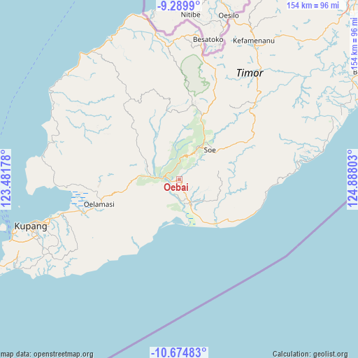
Oebai GPS coordinates[2]
9° 58' 59.16" South, 124° 11' 5.64" East
| Map corner | latitude | longitude |
|---|---|---|
| Upper-left | -9.2899°, | 123.48178° |
| Center: | -9.9831°, | 124.1849° |
| Lower-right: | -10.67483°, | 124.88803° |
| Map W x H: | 154×154 km | = 95.7×95.7mi |
| max Lat: | 5.88969° ⇑96.8% North |
| Oebai: | -9.9831° |
| min Lat: | ⇓3.2% South -10.934° |
| min Long | Oebai | max Long |
| 95.1345° | 124.1849° | 140.9419° |
| W 94.8%⇐ | ⇒5.2% E |
Elevation
Elevation of Oebai is 157 m = 515 ft, and this is 72.7 m = 239 ft below average elevation for this country.
| Max E: |
3185 m = 10449 ft | 40.6% |
| Avg. | 229.7 m = 754 ft | |
| Oebai | 157 m = 515 ft | |
Min E: |
-1 m = -3 ft | 59.4% |
See also: Indonesia elevation on elevation.city.
Geographical zone
Oebai is located in South Torrid zone (between Equator and Tropic of Capricorn). Distance of Equator is 1110 km =689.7 mi to North.| Distance of | km | miles | from Oebai |
|---|---|---|---|
| Equator | 1110 | 689.7 | to North |
| Tropic Capricorn | 1495.9 | 929.5 | to South |
| Antarctic Circle | 6291.2 | 3909.2 | to South |
| South Pole | 8897 | 5528.3 | to South |


Nearby cities:
15 places around Oebai: (largest is in red/bold)
• Hane
8.6 km =5.3 mi,  28°
28°
• Kampungtengah
8 km =5 mi,  324°
324°
• Kuafeu
7.2 km =4.5 mi,  296°
296°
• Kuatnana
10.8 km =6.7 mi,  23°
23°
• Luluf
11.5 km =7.1 mi,  147°
147°
• Oehaunu
10.2 km =6.3 mi,  216°
216°
• Oehumusu
5.1 km =3.2 mi, 16°
• Oetaman
7 km =4.3 mi,  183°
183°
• Panite
10.8 km =6.7 mi, 153°
• Polo
10.3 km =6.4 mi, 151°
• Tabu
10.5 km =6.5 mi,  123°
123°
• Taekas
5.6 km =3.5 mi,  345°
345°
• Tuaneten
9.9 km =6.2 mi,  99°
99°
• Tubunaen
5 km =3.1 mi,  275°
275°
• Tubunain
7.3 km =4.5 mi,  271°
271°
Sources, notices
• [Note1] Compared only with cities in Indonesia existing in our database
• [Src1] Map data: © OpenStreetMap contributors (CC-BY-SA)
• [Src2] Other city data from geonames.org with taken over terms of usage.
• [Src3] Geographical zone / Annual Mean Temperature by Robert A. Rohde @ Wikipedia
