Gunungpapan geodata
Gunungpapan (East Java) is a seat of a fourth-order administrative division; located in Indonesia in Asia/Jakarta (GMT+7) time zone. In our database, there are 407 cities with bigger population. Compared to other cities in Indonesia, 73.8% of cities are located further ↓South; 66.9% of cities are located further ←West and 53.6% of cities have lower elevation than Gunungpapan. Note1


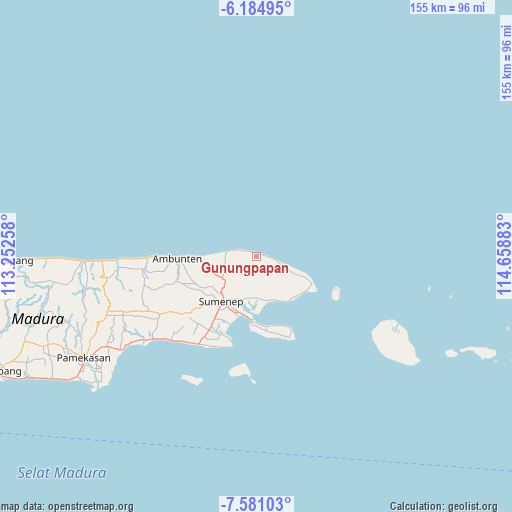
Gunungpapan GPS coordinates[2]
6° 53' 0.6" South, 113° 57' 20.52" East
| Map corner | latitude | longitude |
|---|---|---|
| Upper-left | -6.18495°, | 113.25258° |
| Center: | -6.8835°, | 113.9557° |
| Lower-right: | -7.58103°, | 114.65883° |
| Map W x H: | 155.2×155.2 km | = 96.4×96.4mi |
| max Lat: | 5.88969° ⇑26.2% North |
| Gunungpapan: | -6.8835° |
| min Lat: | ⇓73.8% South -10.934° |
| min Long | Gunungpapan | max Long |
| 95.1345° | 113.9557° | 140.9419° |
| W 66.9%⇐ | ⇒33.1% E |
Elevation
Elevation of Gunungpapan is 117 m = 384 ft, and this is 112.7 m = 370 ft below average elevation for this country.
| Max E: |
3185 m = 10449 ft | 46.4% |
| Avg. | 229.7 m = 754 ft | |
| Gunungpapan | 117 m = 384 ft | |
Min E: |
-1 m = -3 ft | 53.6% |
See also: Indonesia elevation on elevation.city.
Geographical zone
Gunungpapan is located in South Torrid zone (between Equator and Tropic of Capricorn). Distance of Equator is 765.4 km =475.6 mi to North.| Distance of | km | miles | from Gunungpapan |
|---|---|---|---|
| Equator | 765.4 | 475.6 | to North |
| Tropic Capricorn | 1840.5 | 1143.6 | to South |
| Antarctic Circle | 6635.8 | 4123.3 | to South |
| South Pole | 9241.7 | 5742.5 | to South |


Nearby cities:
15 places around Gunungpapan: (largest is in red/bold)
• Batuputih
5.5 km =3.4 mi,  229°
229°
• Bulubarat
4.2 km =2.6 mi,  280°
280°
• Gunung Timur
7.2 km =4.5 mi,  269°
269°
• Jerukporot
8.1 km =5 mi,  141°
141°
• Jurak Lao’
2.6 km =1.6 mi,  176°
176°
• Jurgang Timur
4.6 km =2.9 mi, 138°
• Kayukembang
6.3 km =3.9 mi,  153°
153°
• Marang
8.5 km =5.3 mi,  236°
236°
• Noom Timur
6.9 km =4.3 mi,  190°
190°
• Panjeran
3.7 km =2.3 mi,  210°
210°
• Partikan
7.3 km =4.5 mi,  110°
110°
• Perreng
1.7 km =1.1 mi,  60°
60°
• Talondang
5.8 km =3.6 mi, 275°
• Teramu
7.6 km =4.7 mi, 229°
• Togu
8.4 km =5.2 mi,  168°
168°
Sources, notices
• [Note1] Compared only with cities in Indonesia existing in our database
• [Src1] Map data: © OpenStreetMap contributors (CC-BY-SA)
• [Src2] Other city data from geonames.org with taken over terms of usage.
• [Src3] Geographical zone / Annual Mean Temperature by Robert A. Rohde @ Wikipedia
