Anoek geodata
Anoek (East Nusa Tenggara) is a seat of a fourth-order administrative division; located in Indonesia in Asia/Makassar (GMT+8) time zone. In our database, there are 407 cities with bigger population. Compared to other cities in Indonesia, 94.9% of cities are located further ↑North; 94.4% of cities are located further ←West and 97.6% of cities have lower elevation than Anoek. Note1


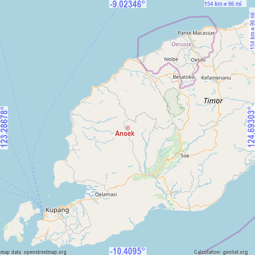
Anoek GPS coordinates[2]
9° 43' 1.92" South, 123° 59' 23.64" East
| Map corner | latitude | longitude |
|---|---|---|
| Upper-left | -9.02346°, | 123.28678° |
| Center: | -9.7172°, | 123.9899° |
| Lower-right: | -10.4095°, | 124.69303° |
| Map W x H: | 154.1×154.1 km | = 95.8×95.8mi |
| max Lat: | 5.88969° ⇑94.9% North |
| Anoek: | -9.7172° |
| min Lat: | ⇓5.1% South -10.934° |
| min Long | Anoek | max Long |
| 95.1345° | 123.9899° | 140.9419° |
| W 94.4%⇐ | ⇒5.6% E |
Elevation
Elevation of Anoek is 1007 m = 3304 ft, and this is 777.3 m = 2550 ft above average elevation for this country.
| Max E: |
3185 m = 10449 ft | 2.4% |
| Anoek | 1007 m 3304 ft | |
| Avg. | 229.7 m = 754 ft | |
Min E: |
-1 m = -3 ft | 97.6% |
See also: Indonesia elevation on elevation.city.
Geographical zone
Anoek is located in South Torrid zone (between Equator and Tropic of Capricorn). Distance of Equator is 1080.5 km =671.4 mi to North.| Distance of | km | miles | from Anoek |
|---|---|---|---|
| Equator | 1080.5 | 671.4 | to North |
| Tropic Capricorn | 1525.5 | 947.9 | to South |
| Antarctic Circle | 6320.7 | 3927.5 | to South |
| South Pole | 8926.6 | 5546.7 | to South |


Nearby cities:
15 places around Anoek: (largest is in red/bold)
• Binafun
7.9 km =4.9 mi,  39°
39°
• Bitobe
9.4 km =5.8 mi,  358°
358°
• Fatumetan
4.9 km =3 mi,  238°
238°
• Fatupael
4 km =2.5 mi,  289°
289°
• Hueknutu
16 km =9.9 mi,  167°
167°
• Huelkail
10.5 km =6.5 mi,  7°
7°
• Kaem
14.9 km =9.3 mi,  245°
245°
• Leloboko
6.9 km =4.3 mi, 285°
• Lelogama
4 km =2.5 mi,  279°
279°
• Liliana
16.6 km =10.3 mi,  82°
82°
• Meobesi
14.3 km =8.9 mi,  183°
183°
• Oelbanu
10 km =6.2 mi, 277°
• Oenenas
5.1 km =3.2 mi,  27°
27°
• Oepula
9.5 km =5.9 mi,  162°
162°
• Taimaman
13.9 km =8.6 mi,  223°
223°
Sources, notices
• [Note1] Compared only with cities in Indonesia existing in our database
• [Src1] Map data: © OpenStreetMap contributors (CC-BY-SA)
• [Src2] Other city data from geonames.org with taken over terms of usage.
• [Src3] Geographical zone / Annual Mean Temperature by Robert A. Rohde @ Wikipedia
