Naip geodata
Naip (East Nusa Tenggara) is a seat of a fourth-order administrative division; located in Indonesia in Asia/Makassar (GMT+8) time zone. In our database, there are 407 cities with bigger population. Compared to other cities in Indonesia, 97% of cities are located further ↑North; 95.7% of cities are located further ←West and 68.4% of cities have lower elevation than Naip. Note1


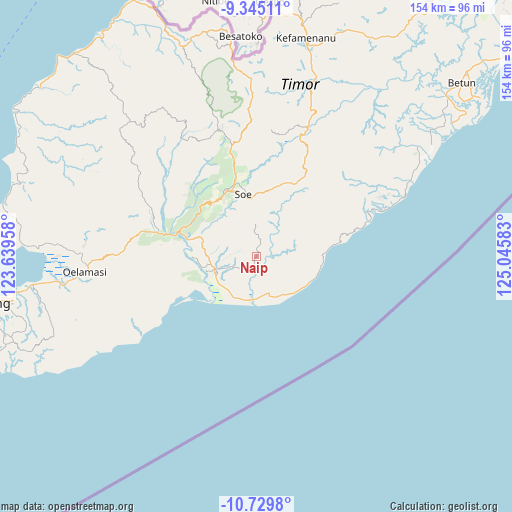
Naip GPS coordinates[2]
10° 2' 17.52" South, 124° 20' 33.72" East
| Map corner | latitude | longitude |
|---|---|---|
| Upper-left | -9.34511°, | 123.63958° |
| Center: | -10.0382°, | 124.3427° |
| Lower-right: | -10.7298°, | 125.04583° |
| Map W x H: | 154×154 km | = 95.7×95.7mi |
| max Lat: | 5.88969° ⇑97% North |
| Naip: | -10.0382° |
| min Lat: | ⇓3% South -10.934° |
| min Long | Naip | max Long |
| 95.1345° | 124.3427° | 140.9419° |
| W 95.7%⇐ | ⇒4.3% E |
Elevation
Elevation of Naip is 270 m = 886 ft, and this is 40.3 m = 132 ft above average elevation for this country.
| Max E: |
3185 m = 10449 ft | 31.6% |
| Naip | 270 m 886 ft | |
| Avg. | 229.7 m = 754 ft | |
Min E: |
-1 m = -3 ft | 68.4% |
See also: Indonesia elevation on elevation.city.
Geographical zone
Naip is located in South Torrid zone (between Equator and Tropic of Capricorn). Distance of Equator is 1116.1 km =693.5 mi to North.| Distance of | km | miles | from Naip |
|---|---|---|---|
| Equator | 1116.1 | 693.5 | to North |
| Tropic Capricorn | 1489.8 | 925.7 | to South |
| Antarctic Circle | 6285 | 3905.3 | to South |
| South Pole | 8890.9 | 5524.5 | to South |


Nearby cities:
15 places around Naip: (largest is in red/bold)
• Belua
12.2 km =7.6 mi,  18°
18°
• Fauthanin
10.7 km =6.6 mi,  80°
80°
• Kotai
7.2 km =4.5 mi,  98°
98°
• Kuafeu
9.9 km =6.2 mi,  65°
65°
• Kuanfatu
11.6 km =7.2 mi, 81°
• Lani
12.8 km =8 mi,  114°
114°
• Luluf
11.6 km =7.2 mi,  252°
252°
• Naensaet
5.9 km =3.7 mi,  348°
348°
• Nunmanu
0.7 km =0.4 mi,  222°
222°
• Oekiu
5.6 km =3.5 mi,  232°
232°
• Suman
3.1 km =1.9 mi,  175°
175°
• Tabu
8.5 km =5.3 mi,  272°
272°
• Tuanalepe
11.3 km =7 mi,  344°
344°
• Tuaneten
8.7 km =5.4 mi,  301°
301°
• Tutnae
9 km =5.6 mi,  135°
135°
Sources, notices
• [Note1] Compared only with cities in Indonesia existing in our database
• [Src1] Map data: © OpenStreetMap contributors (CC-BY-SA)
• [Src2] Other city data from geonames.org with taken over terms of usage.
• [Src3] Geographical zone / Annual Mean Temperature by Robert A. Rohde @ Wikipedia
