Tubel geodata
Tubel (East Nusa Tenggara) is a seat of a fourth-order administrative division; located in Indonesia in Asia/Makassar (GMT+8) time zone. In our database, there are 407 cities with bigger population. Compared to other cities in Indonesia, 96.6% of cities are located further ↑North; 96.7% of cities are located further ←West and 90.6% of cities have lower elevation than Tubel. Note1


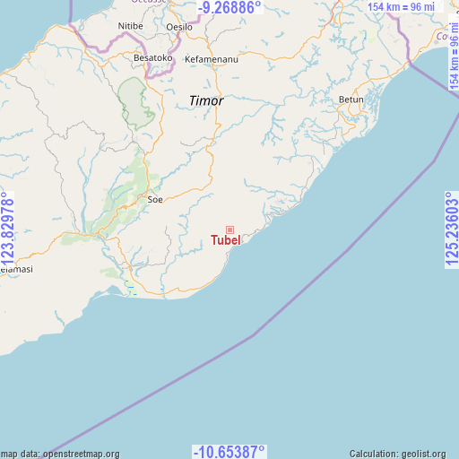
Tubel GPS coordinates[2]
9° 57' 43.56" South, 124° 31' 58.44" East
| Map corner | latitude | longitude |
|---|---|---|
| Upper-left | -9.26886°, | 123.82978° |
| Center: | -9.9621°, | 124.5329° |
| Lower-right: | -10.65387°, | 125.23603° |
| Map W x H: | 154×154 km | = 95.7×95.7mi |
| max Lat: | 5.88969° ⇑96.6% North |
| Tubel: | -9.9621° |
| min Lat: | ⇓3.4% South -10.934° |
| min Long | Tubel | max Long |
| 95.1345° | 124.5329° | 140.9419° |
| W 96.7%⇐ | ⇒3.3% E |
Elevation
Elevation of Tubel is 661 m = 2169 ft, and this is 431.3 m = 1415 ft above average elevation for this country.
| Max E: |
3185 m = 10449 ft | 9.4% |
| Tubel | 661 m 2169 ft | |
| Avg. | 229.7 m = 754 ft | |
Min E: |
-1 m = -3 ft | 90.6% |
See also: Indonesia elevation on elevation.city.
Geographical zone
Tubel is located in South Torrid zone (between Equator and Tropic of Capricorn). Distance of Equator is 1107.7 km =688.3 mi to North.| Distance of | km | miles | from Tubel |
|---|---|---|---|
| Equator | 1107.7 | 688.3 | to North |
| Tropic Capricorn | 1498.2 | 930.9 | to South |
| Antarctic Circle | 6293.5 | 3910.6 | to South |
| South Pole | 8899.4 | 5529.8 | to South |


Nearby cities:
15 places around Tubel: (largest is in red/bold)
• Amononi
5.3 km =3.3 mi,  271°
271°
• Baki
7.4 km =4.6 mi,  299°
299°
• Haunubenak
1.6 km =1 mi,  13°
13°
• Kakan
9 km =5.6 mi,  237°
237°
• Kolbano
8.2 km =5.1 mi,  188°
188°
• Nifufuni
5.8 km =3.6 mi,  294°
294°
• Oeekam
2.6 km =1.6 mi,  306°
306°
• Oefau
6.2 km =3.9 mi,  358°
358°
• Oelui
7.7 km =4.8 mi,  276°
276°
• Oetuke
4 km =2.5 mi,  143°
143°
• Olin
7.2 km =4.5 mi,  89°
89°
• Oobibi
6.3 km =3.9 mi,  72°
72°
• Oof
8.9 km =5.5 mi,  263°
263°
• Poto
8 km =5 mi,  37°
37°
• Timutuka
3.9 km =2.4 mi,  178°
178°
Sources, notices
• [Note1] Compared only with cities in Indonesia existing in our database
• [Src1] Map data: © OpenStreetMap contributors (CC-BY-SA)
• [Src2] Other city data from geonames.org with taken over terms of usage.
• [Src3] Geographical zone / Annual Mean Temperature by Robert A. Rohde @ Wikipedia
