Oobibi geodata
Oobibi (East Nusa Tenggara) is a seat of a fourth-order administrative division; located in Indonesia in Asia/Makassar (GMT+8) time zone. In our database, there are 407 cities with bigger population. Compared to other cities in Indonesia, 96.5% of cities are located further ↑North; 97% of cities are located further ←West and 88.6% of cities have lower elevation than Oobibi. Note1


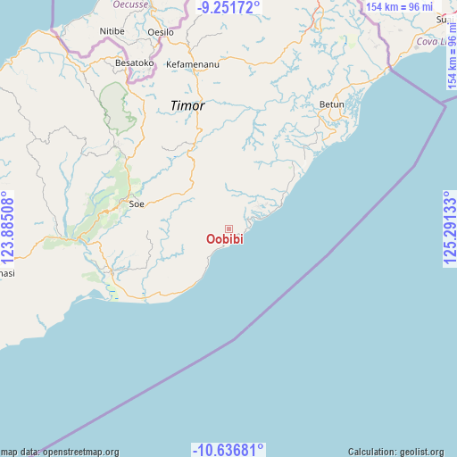
Oobibi GPS coordinates[2]
9° 56' 42" South, 124° 35' 17.52" East
| Map corner | latitude | longitude |
|---|---|---|
| Upper-left | -9.25172°, | 123.88508° |
| Center: | -9.945°, | 124.5882° |
| Lower-right: | -10.63681°, | 125.29133° |
| Map W x H: | 154×154 km | = 95.7×95.7mi |
| max Lat: | 5.88969° ⇑96.5% North |
| Oobibi: | -9.945° |
| min Lat: | ⇓3.5% South -10.934° |
| min Long | Oobibi | max Long |
| 95.1345° | 124.5882° | 140.9419° |
| W 97%⇐ | ⇒3% E |
Elevation
Elevation of Oobibi is 599 m = 1965 ft, and this is 369.3 m = 1212 ft above average elevation for this country.
| Max E: |
3185 m = 10449 ft | 11.4% |
| Oobibi | 599 m 1965 ft | |
| Avg. | 229.7 m = 754 ft | |
Min E: |
-1 m = -3 ft | 88.6% |
See also: Indonesia elevation on elevation.city.
Geographical zone
Oobibi is located in South Torrid zone (between Equator and Tropic of Capricorn). Distance of Equator is 1105.8 km =687.1 mi to North.| Distance of | km | miles | from Oobibi |
|---|---|---|---|
| Equator | 1105.8 | 687.1 | to North |
| Tropic Capricorn | 1500.1 | 932.1 | to South |
| Antarctic Circle | 6295.4 | 3911.8 | to South |
| South Pole | 8901.3 | 5531 | to South |


Nearby cities:
15 places around Oobibi: (largest is in red/bold)
• Ayofanu
7.8 km =4.8 mi,  2°
2°
• Fatuulan
5.1 km =3.2 mi,  33°
33°
• Haumeni
10 km =6.2 mi,  48°
48°
• Haunubenak
5.7 km =3.5 mi,  266°
266°
• Nunleu
8.3 km =5.2 mi, 28°
• Nunutoko
4.9 km =3 mi,  94°
94°
• Oebubun
9.7 km =6 mi,  8°
8°
• Oeekam
8.1 km =5 mi, 267°
• Oefau
7.6 km =4.7 mi,  304°
304°
• Oetuke
6.3 km =3.9 mi,  216°
216°
• Olin
2.2 km =1.4 mi,  147°
147°
• Op
7.3 km =4.5 mi,  62°
62°
• Poto
4.6 km =2.9 mi,  344°
344°
• Timutuka
8.3 km =5.2 mi,  225°
225°
• Tubel
6.3 km =3.9 mi,  252°
252°
Sources, notices
• [Note1] Compared only with cities in Indonesia existing in our database
• [Src1] Map data: © OpenStreetMap contributors (CC-BY-SA)
• [Src2] Other city data from geonames.org with taken over terms of usage.
• [Src3] Geographical zone / Annual Mean Temperature by Robert A. Rohde @ Wikipedia
