Poto geodata
Poto (East Nusa Tenggara) is a seat of a fourth-order administrative division; located in Indonesia in Asia/Makassar (GMT+8) time zone. In our database, there are 407 cities with bigger population. Compared to other cities in Indonesia, 96.3% of cities are located further ↑North; 96.9% of cities are located further ←West and 96.3% of cities have lower elevation than Poto. Note1


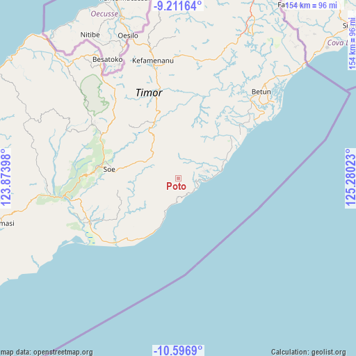
Poto GPS coordinates[2]
9° 54' 18" South, 124° 34' 37.56" East
| Map corner | latitude | longitude |
|---|---|---|
| Upper-left | -9.21164°, | 123.87398° |
| Center: | -9.905°, | 124.5771° |
| Lower-right: | -10.5969°, | 125.28023° |
| Map W x H: | 154×154 km | = 95.7×95.7mi |
| max Lat: | 5.88969° ⇑96.3% North |
| Poto: | -9.905° |
| min Lat: | ⇓3.7% South -10.934° |
| min Long | Poto | max Long |
| 95.1345° | 124.5771° | 140.9419° |
| W 96.9%⇐ | ⇒3.1% E |
Elevation
Elevation of Poto is 895 m = 2936 ft, and this is 665.3 m = 2183 ft above average elevation for this country.
| Max E: |
3185 m = 10449 ft | 3.7% |
| Poto | 895 m 2936 ft | |
| Avg. | 229.7 m = 754 ft | |
Min E: |
-1 m = -3 ft | 96.3% |
See also: Indonesia elevation on elevation.city.
Geographical zone
Poto is located in South Torrid zone (between Equator and Tropic of Capricorn). Distance of Equator is 1101.3 km =684.3 mi to North.| Distance of | km | miles | from Poto |
|---|---|---|---|
| Equator | 1101.3 | 684.3 | to North |
| Tropic Capricorn | 1504.6 | 934.9 | to South |
| Antarctic Circle | 6299.8 | 3914.5 | to South |
| South Pole | 8905.7 | 5533.7 | to South |


Nearby cities:
15 places around Poto: (largest is in red/bold)
• Anin
6.9 km =4.3 mi,  1°
1°
• Ayofanu
3.6 km =2.2 mi,  24°
24°
• Fatuulan
4 km =2.5 mi,  93°
93°
• Haunubenak
6.5 km =4 mi,  223°
223°
• Kie
7.4 km =4.6 mi,  334°
334°
• Nunleu
5.9 km =3.7 mi,  61°
61°
• Nunutoko
7.8 km =4.8 mi,  128°
128°
• Oebubun
5.8 km =3.6 mi,  27°
27°
• Oefau
5 km =3.1 mi,  268°
268°
• Oenpeotnai
5.9 km =3.7 mi,  353°
353°
• Oinlasi
6.1 km =3.8 mi,  357°
357°
• Olin
6.7 km =4.2 mi,  159°
159°
• Oobibi
4.6 km =2.9 mi, 164°
• Op
7.8 km =4.8 mi,  98°
98°
• Tubel
8 km =5 mi, 217°
Sources, notices
• [Note1] Compared only with cities in Indonesia existing in our database
• [Src1] Map data: © OpenStreetMap contributors (CC-BY-SA)
• [Src2] Other city data from geonames.org with taken over terms of usage.
• [Src3] Geographical zone / Annual Mean Temperature by Robert A. Rohde @ Wikipedia
