Noebana geodata
Noebana (East Nusa Tenggara) is a seat of a fourth-order administrative division; located in Indonesia in Asia/Makassar (GMT+8) time zone. In our database, there are 407 cities with bigger population. Compared to other cities in Indonesia, 95.3% of cities are located further ↑North; 97.3% of cities are located further ←West and 80.3% of cities have lower elevation than Noebana. Note1


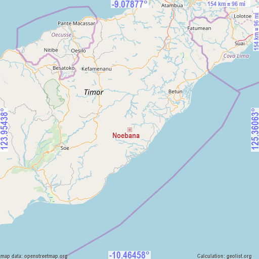
Noebana GPS coordinates[2]
9° 46' 20.64" South, 124° 39' 27" East
| Map corner | latitude | longitude |
|---|---|---|
| Upper-left | -9.07877°, | 123.95438° |
| Center: | -9.7724°, | 124.6575° |
| Lower-right: | -10.46458°, | 125.36063° |
| Map W x H: | 154.1×154.1 km | = 95.8×95.8mi |
| max Lat: | 5.88969° ⇑95.3% North |
| Noebana: | -9.7724° |
| min Lat: | ⇓4.7% South -10.934° |
| min Long | Noebana | max Long |
| 95.1345° | 124.6575° | 140.9419° |
| W 97.3%⇐ | ⇒2.7% E |
Elevation
Elevation of Noebana is 435 m = 1427 ft, and this is 205.3 m = 674 ft above average elevation for this country.
| Max E: |
3185 m = 10449 ft | 19.7% |
| Noebana | 435 m 1427 ft | |
| Avg. | 229.7 m = 754 ft | |
Min E: |
-1 m = -3 ft | 80.3% |
See also: Indonesia elevation on elevation.city.
Geographical zone
Noebana is located in South Torrid zone (between Equator and Tropic of Capricorn). Distance of Equator is 1086.6 km =675.2 mi to North.| Distance of | km | miles | from Noebana |
|---|---|---|---|
| Equator | 1086.6 | 675.2 | to North |
| Tropic Capricorn | 1519.3 | 944 | to South |
| Antarctic Circle | 6314.6 | 3923.7 | to South |
| South Pole | 8920.5 | 5542.9 | to South |


Nearby cities:
15 places around Noebana: (largest is in red/bold)
• Fatuhilik
6.8 km =4.2 mi,  239°
239°
• Fotilo
5.6 km =3.5 mi,  44°
44°
• Koana
7.3 km =4.5 mi,  149°
149°
• Linakelopu
7.1 km =4.4 mi, 237°
• Malla
4.7 km =2.9 mi,  120°
120°
• Manufui
7.8 km =4.8 mi,  104°
104°
• Mnelabano
6.8 km =4.2 mi,  11°
11°
• Nenotes
4.4 km =2.7 mi, 151°
• Oefenu
2.5 km =1.6 mi,  45°
45°
• Pisan
7.7 km =4.8 mi,  301°
301°
• Poli
5 km =3.1 mi,  84°
84°
• Sbo’o
7.4 km =4.6 mi,  182°
182°
• Sunu
5.5 km =3.4 mi,  198°
198°
• Tuateta
5.6 km =3.5 mi,  351°
351°
• Tunis
5.9 km =3.7 mi,  283°
283°
Sources, notices
• [Note1] Compared only with cities in Indonesia existing in our database
• [Src1] Map data: © OpenStreetMap contributors (CC-BY-SA)
• [Src2] Other city data from geonames.org with taken over terms of usage.
• [Src3] Geographical zone / Annual Mean Temperature by Robert A. Rohde @ Wikipedia
