Bunggeta geodata
Bunggeta (East Nusa Tenggara) is a seat of a fourth-order administrative division; located in Indonesia in Asia/Makassar (GMT+8) time zone. In our database, there are 407 cities with bigger population. Compared to other cities in Indonesia, 78.5% of cities are located further ↑North; 97.2% of cities are located further ←West and 96.2% of cities have lower elevation than Bunggeta. Note1


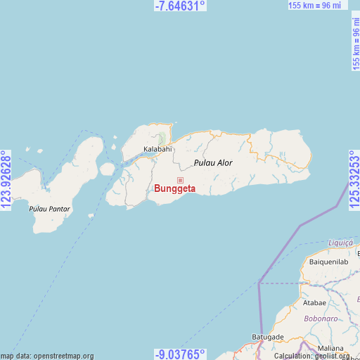
Bunggeta GPS coordinates[2]
8° 20' 33.36" South, 124° 37' 45.84" East
| Map corner | latitude | longitude |
|---|---|---|
| Upper-left | -7.64631°, | 123.92628° |
| Center: | -8.3426°, | 124.6294° |
| Lower-right: | -9.03765°, | 125.33253° |
| Map W x H: | 154.7×154.7 km | = 96.1×96.1mi |
| max Lat: | 5.88969° ⇑78.5% North |
| Bunggeta: | -8.3426° |
| min Lat: | ⇓21.5% South -10.934° |
| min Long | Bunggeta | max Long |
| 95.1345° | 124.6294° | 140.9419° |
| W 97.2%⇐ | ⇒2.8% E |
Elevation
Elevation of Bunggeta is 892 m = 2927 ft, and this is 662.3 m = 2173 ft above average elevation for this country.
| Max E: |
3185 m = 10449 ft | 3.8% |
| Bunggeta | 892 m 2927 ft | |
| Avg. | 229.7 m = 754 ft | |
Min E: |
-1 m = -3 ft | 96.2% |
See also: Indonesia elevation on elevation.city.
Geographical zone
Bunggeta is located in South Torrid zone (between Equator and Tropic of Capricorn). Distance of Equator is 927.6 km =576.4 mi to North.| Distance of | km | miles | from Bunggeta |
|---|---|---|---|
| Equator | 927.6 | 576.4 | to North |
| Tropic Capricorn | 1678.3 | 1042.8 | to South |
| Antarctic Circle | 6473.6 | 4022.5 | to South |
| South Pole | 9079.5 | 5641.7 | to South |


Nearby cities:
15 places around Bunggeta: (largest is in red/bold)
• Apui
12.9 km =8 mi,  53°
53°
• Atengmelang
13.7 km =8.5 mi,  19°
19°
• Kalunan
6.8 km =4.2 mi,  140°
140°
• Kikilai
14.6 km =9.1 mi,  306°
306°
• Kiraman
14.8 km =9.2 mi,  115°
115°
• Maikawada
11.4 km =7.1 mi, 53°
• Mainang
6.6 km =4.1 mi,  356°
356°
• Maiwal
12.3 km =7.6 mi,  279°
279°
• Makemi
15.7 km =9.8 mi, 24°
• Masape
9.2 km =5.7 mi, 45°
• Padangalang
10.1 km =6.3 mi,  113°
113°
• Sifala
14.1 km =8.8 mi,  221°
221°
• Silonang
10.4 km =6.5 mi,  77°
77°
• Tukbur
6.2 km =3.9 mi,  145°
145°
• Welai
14.1 km =8.8 mi,  327°
327°
Sources, notices
• [Note1] Compared only with cities in Indonesia existing in our database
• [Src1] Map data: © OpenStreetMap contributors (CC-BY-SA)
• [Src2] Other city data from geonames.org with taken over terms of usage.
• [Src3] Geographical zone / Annual Mean Temperature by Robert A. Rohde @ Wikipedia
