Sifala geodata
Sifala (East Nusa Tenggara) is a seat of a fourth-order administrative division; located in Indonesia in Asia/Makassar (GMT+8) time zone. In our database, there are 407 cities with bigger population. Compared to other cities in Indonesia, 81.4% of cities are located further ↑North; 96.8% of cities are located further ←West and 66.4% of cities have higher elevation than Sifala. Note1


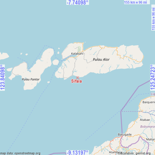
Sifala GPS coordinates[2]
8° 26' 13.56" South, 124° 32' 38.76" East
| Map corner | latitude | longitude |
|---|---|---|
| Upper-left | -7.74098°, | 123.84098° |
| Center: | -8.4371°, | 124.5441° |
| Lower-right: | -9.13197°, | 125.24723° |
| Map W x H: | 154.7×154.7 km | = 96.1×96.1mi |
| max Lat: | 5.88969° ⇑81.4% North |
| Sifala: | -8.4371° |
| min Lat: | ⇓18.6% South -10.934° |
| min Long | Sifala | max Long |
| 95.1345° | 124.5441° | 140.9419° |
| W 96.8%⇐ | ⇒3.2% E |
Elevation
Elevation of Sifala is 39 m = 128 ft, and this is 190.7 m = 626 ft below average elevation for this country.
| Max E: |
3185 m = 10449 ft | 66.4% |
| Avg. | 229.7 m = 754 ft | |
| Sifala | 39 m = 128 ft | |
Min E: |
-1 m = -3 ft | 33.6% |
See also: Indonesia elevation on elevation.city.
Geographical zone
Sifala is located in South Torrid zone (between Equator and Tropic of Capricorn). Distance of Equator is 938.1 km =582.9 mi to North.| Distance of | km | miles | from Sifala |
|---|---|---|---|
| Equator | 938.1 | 582.9 | to North |
| Tropic Capricorn | 1667.8 | 1036.3 | to South |
| Antarctic Circle | 6463.1 | 4016 | to South |
| South Pole | 9068.9 | 5635.2 | to South |


Nearby cities:
15 places around Sifala: (largest is in red/bold)
• Bunggeta
14.1 km =8.8 mi,  41°
41°
• Buraga
6.5 km =4 mi,  286°
286°
• Dulolong
22.9 km =14.2 mi,  332°
332°
• Fa’aming
21.2 km =13.2 mi, 330°
• Kalunan
14.6 km =9.1 mi,  69°
69°
• Kikilai
19.3 km =12 mi,  353°
353°
• Kiraman
23.1 km =14.4 mi,  79°
79°
• Lewolang
23 km =14.3 mi, 326°
• Mainang
19.3 km =12 mi,  27°
27°
• Maiwal
12.8 km =8 mi, 347°
• Mataraben
15.6 km =9.7 mi,  296°
296°
• Moru
20.3 km =12.6 mi, 351°
• Padangalang
19.8 km =12.3 mi, 70°
• Tukbur
14 km =8.7 mi, 67°
• Welai
22.5 km =14 mi,  4°
4°
Sources, notices
• [Note1] Compared only with cities in Indonesia existing in our database
• [Src1] Map data: © OpenStreetMap contributors (CC-BY-SA)
• [Src2] Other city data from geonames.org with taken over terms of usage.
• [Src3] Geographical zone / Annual Mean Temperature by Robert A. Rohde @ Wikipedia
