Kalunan geodata
Kalunan (East Nusa Tenggara) is a seat of a fourth-order administrative division; located in Indonesia in Asia/Makassar (GMT+8) time zone. In our database, there are 407 cities with bigger population. Compared to other cities in Indonesia, 80.1% of cities are located further ↑North; 97.4% of cities are located further ←West and 84.2% of cities have higher elevation than Kalunan. Note1


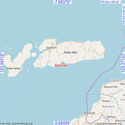
Kalunan GPS coordinates[2]
8° 23' 24" South, 124° 40' 5.88" East
| Map corner | latitude | longitude |
|---|---|---|
| Upper-left | -7.69379°, | 123.96518° |
| Center: | -8.39°, | 124.6683° |
| Lower-right: | -9.08496°, | 125.37143° |
| Map W x H: | 154.7×154.7 km | = 96.1×96.1mi |
| max Lat: | 5.88969° ⇑80.1% North |
| Kalunan: | -8.39° |
| min Lat: | ⇓19.9% South -10.934° |
| min Long | Kalunan | max Long |
| 95.1345° | 124.6683° | 140.9419° |
| W 97.4%⇐ | ⇒2.6% E |
Elevation
Elevation of Kalunan is 15 m = 49 ft, and this is 214.7 m = 704 ft below average elevation for this country.
| Max E: |
3185 m = 10449 ft | 84.2% |
| Avg. | 229.7 m = 754 ft | |
| Kalunan | 15 m = 49 ft | |
Min E: |
-1 m = -3 ft | 15.8% |
See also: Indonesia elevation on elevation.city.
Geographical zone
Kalunan is located in South Torrid zone (between Equator and Tropic of Capricorn). Distance of Equator is 932.9 km =579.7 mi to North.| Distance of | km | miles | from Kalunan |
|---|---|---|---|
| Equator | 932.9 | 579.7 | to North |
| Tropic Capricorn | 1673 | 1039.6 | to South |
| Antarctic Circle | 6468.3 | 4019.2 | to South |
| South Pole | 9074.2 | 5638.4 | to South |


Nearby cities:
15 places around Kalunan: (largest is in red/bold)
• Apui
14.3 km =8.9 mi,  24°
24°
• Atengmelang
18.2 km =11.3 mi,  0°
0°
• Bunggeta
6.8 km =4.2 mi,  320°
320°
• Buraga
20.2 km =12.6 mi,  260°
260°
• Kiraman
9.1 km =5.7 mi,  97°
97°
• Mademang
18.3 km =11.4 mi,  88°
88°
• Maikawada
13 km =8.1 mi, 22°
• Mainang
12.8 km =8 mi,  338°
338°
• Maiwal
18 km =11.2 mi,  293°
293°
• Makemi
19.6 km =12.2 mi,  6°
6°
• Masape
11.9 km =7.4 mi, 11°
• Padangalang
5.2 km =3.2 mi,  75°
75°
• Sifala
14.6 km =9.1 mi,  249°
249°
• Silonang
9.6 km =6 mi,  37°
37°
• Tukbur
0.8 km =0.5 mi,  283°
283°
Sources, notices
• [Note1] Compared only with cities in Indonesia existing in our database
• [Src1] Map data: © OpenStreetMap contributors (CC-BY-SA)
• [Src2] Other city data from geonames.org with taken over terms of usage.
• [Src3] Geographical zone / Annual Mean Temperature by Robert A. Rohde @ Wikipedia
