Boto geodata
Boto (East Nusa Tenggara) is a seat of a fourth-order administrative division; located in Indonesia in Asia/Makassar (GMT+8) time zone. In our database, there are 407 cities with bigger population. Compared to other cities in Indonesia, 83.7% of cities are located further ↑North; 91.9% of cities are located further ←West and 86.1% of cities have lower elevation than Boto. Note1


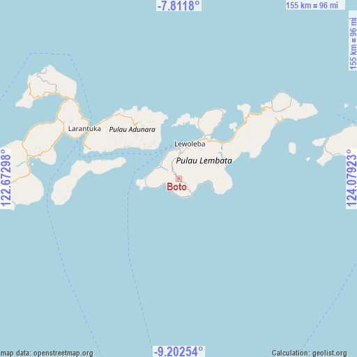
Boto GPS coordinates[2]
8° 30' 28.08" South, 123° 22' 33.96" East
| Map corner | latitude | longitude |
|---|---|---|
| Upper-left | -7.8118°, | 122.67298° |
| Center: | -8.5078°, | 123.3761° |
| Lower-right: | -9.20254°, | 124.07923° |
| Map W x H: | 154.6×154.6 km | = 96.1×96.1mi |
| max Lat: | 5.88969° ⇑83.7% North |
| Boto: | -8.5078° |
| min Lat: | ⇓16.3% South -10.934° |
| min Long | Boto | max Long |
| 95.1345° | 123.3761° | 140.9419° |
| W 91.9%⇐ | ⇒8.1% E |
Elevation
Elevation of Boto is 539 m = 1768 ft, and this is 309.3 m = 1015 ft above average elevation for this country.
| Max E: |
3185 m = 10449 ft | 13.9% |
| Boto | 539 m 1768 ft | |
| Avg. | 229.7 m = 754 ft | |
Min E: |
-1 m = -3 ft | 86.1% |
See also: Indonesia elevation on elevation.city.
Geographical zone
Boto is located in South Torrid zone (between Equator and Tropic of Capricorn). Distance of Equator is 946 km =587.8 mi to North.| Distance of | km | miles | from Boto |
|---|---|---|---|
| Equator | 946 | 587.8 | to North |
| Tropic Capricorn | 1659.9 | 1031.4 | to South |
| Antarctic Circle | 6455.2 | 4011.1 | to South |
| South Pole | 9061.1 | 5630.3 | to South |


Nearby cities:
15 places around Boto: (largest is in red/bold)
• Bakan
11.4 km =7.1 mi,  65°
65°
• Batanamang
8.8 km =5.5 mi,  150°
150°
• Belang
8.9 km =5.5 mi,  348°
348°
• Idalolong
6.4 km =4 mi,  247°
247°
• Imulolong
5.4 km =3.4 mi,  139°
139°
• Lamabaka
8.4 km =5.2 mi,  159°
159°
• Lamalera
9.1 km =5.7 mi, 144°
• Lamalewar
3.3 km =2.1 mi,  323°
323°
• Lewokukung
10.3 km =6.4 mi,  49°
49°
• Lewopenutung
6.5 km =4 mi,  201°
201°
• Lewuka
8 km =5 mi,  82°
82°
• Loang
10.8 km =6.7 mi,  292°
292°
• Luki
8.8 km =5.5 mi,  106°
106°
• Paobokol
4 km =2.5 mi, 52°
• Puor
4.9 km =3 mi,  129°
129°
Sources, notices
• [Note1] Compared only with cities in Indonesia existing in our database
• [Src1] Map data: © OpenStreetMap contributors (CC-BY-SA)
• [Src2] Other city data from geonames.org with taken over terms of usage.
• [Src3] Geographical zone / Annual Mean Temperature by Robert A. Rohde @ Wikipedia
