Ongalereng geodata
Ongalereng (East Nusa Tenggara) is a seat of a fourth-order administrative division; located in Indonesia in Asia/Makassar (GMT+8) time zone. In our database, there are 407 cities with bigger population. Compared to other cities in Indonesia, 81.6% of cities are located further ↑North; 90.3% of cities are located further ←West and 65.2% of cities have higher elevation than Ongalereng. Note1


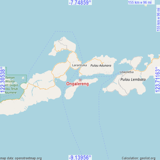
Ongalereng GPS coordinates[2]
8° 26' 40.92" South, 123° 0' 30.6" East
| Map corner | latitude | longitude |
|---|---|---|
| Upper-left | -7.74859°, | 122.30538° |
| Center: | -8.4447°, | 123.0085° |
| Lower-right: | -9.13956°, | 123.71163° |
| Map W x H: | 154.7×154.7 km | = 96.1×96.1mi |
| max Lat: | 5.88969° ⇑81.6% North |
| Ongalereng: | -8.4447° |
| min Lat: | ⇓18.4% South -10.934° |
| min Long | Ongalereng | max Long |
| 95.1345° | 123.0085° | 140.9419° |
| W 90.3%⇐ | ⇒9.7% E |
Elevation
Elevation of Ongalereng is 42 m = 138 ft, and this is 187.7 m = 616 ft below average elevation for this country.
| Max E: |
3185 m = 10449 ft | 65.2% |
| Avg. | 229.7 m = 754 ft | |
| Ongalereng | 42 m = 138 ft | |
Min E: |
-1 m = -3 ft | 34.8% |
See also: Indonesia elevation on elevation.city.
Geographical zone
Ongalereng is located in South Torrid zone (between Equator and Tropic of Capricorn). Distance of Equator is 939 km =583.5 mi to North.| Distance of | km | miles | from Ongalereng |
|---|---|---|---|
| Equator | 939 | 583.5 | to North |
| Tropic Capricorn | 1667 | 1035.8 | to South |
| Antarctic Circle | 6462.2 | 4015.4 | to South |
| South Pole | 9068.1 | 5634.7 | to South |


Nearby cities:
15 places around Ongalereng: (largest is in red/bold)
• Basarani
6.6 km =4.1 mi,  38°
38°
• Daniwato
7.9 km =4.9 mi,  232°
232°
• Haridimun
5.3 km =3.3 mi,  188°
188°
• Karawatung
1.2 km =0.7 mi,  129°
129°
• Lamagohang
4 km =2.5 mi,  167°
167°
• Lamalewo
5.1 km =3.2 mi,  263°
263°
• Lewograran
4.2 km =2.6 mi,  145°
145°
• Lohayong
6.7 km =4.2 mi,  80°
80°
• Pamakayo
2.9 km =1.8 mi,  287°
287°
• Rianglaka
6.6 km =4.1 mi,  243°
243°
• Sulengwaseng
7.8 km =4.8 mi,  207°
207°
• Wailebe
8.4 km =5.2 mi,  353°
353°
• Waiwukak
7.5 km =4.7 mi,  56°
56°
• Woto
6.4 km =4 mi,  4°
4°
• Wulublolong
3.7 km =2.3 mi, 80°
Sources, notices
• [Note1] Compared only with cities in Indonesia existing in our database
• [Src1] Map data: © OpenStreetMap contributors (CC-BY-SA)
• [Src2] Other city data from geonames.org with taken over terms of usage.
• [Src3] Geographical zone / Annual Mean Temperature by Robert A. Rohde @ Wikipedia
