Lamalewo geodata
Lamalewo (East Nusa Tenggara) is a seat of a fourth-order administrative division; located in Indonesia in Asia/Makassar (GMT+8) time zone. In our database, there are 407 cities with bigger population. Compared to other cities in Indonesia, 81.7% of cities are located further ↑North; 90% of cities are located further ←West and 68% of cities have higher elevation than Lamalewo. Note1


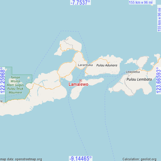
Lamalewo GPS coordinates[2]
8° 26' 59.28" South, 122° 57' 46.08" East
| Map corner | latitude | longitude |
|---|---|---|
| Upper-left | -7.7537°, | 122.25968° |
| Center: | -8.4498°, | 122.9628° |
| Lower-right: | -9.14465°, | 123.66593° |
| Map W x H: | 154.7×154.7 km | = 96.1×96.1mi |
| max Lat: | 5.88969° ⇑81.7% North |
| Lamalewo: | -8.4498° |
| min Lat: | ⇓18.3% South -10.934° |
| min Long | Lamalewo | max Long |
| 95.1345° | 122.9628° | 140.9419° |
| W 90%⇐ | ⇒10% E |
Elevation
Elevation of Lamalewo is 36 m = 118 ft, and this is 193.7 m = 635 ft below average elevation for this country.
| Max E: |
3185 m = 10449 ft | 68% |
| Avg. | 229.7 m = 754 ft | |
| Lamalewo | 36 m = 118 ft | |
Min E: |
-1 m = -3 ft | 32% |
See also: Indonesia elevation on elevation.city.
Geographical zone
Lamalewo is located in South Torrid zone (between Equator and Tropic of Capricorn). Distance of Equator is 939.5 km =583.8 mi to North.| Distance of | km | miles | from Lamalewo |
|---|---|---|---|
| Equator | 939.5 | 583.8 | to North |
| Tropic Capricorn | 1666.4 | 1035.5 | to South |
| Antarctic Circle | 6461.6 | 4015.1 | to South |
| South Pole | 9067.5 | 5634.3 | to South |


Nearby cities:
15 places around Lamalewo: (largest is in red/bold)
• Basarani
10.8 km =6.7 mi,  58°
58°
• Daniwato
4.5 km =2.8 mi,  196°
196°
• Haridimun
6.4 km =4 mi,  137°
137°
• Kalelu
10.6 km =6.6 mi, 195°
• Karawatung
6 km =3.7 mi,  91°
91°
• Lamagohang
6.8 km =4.2 mi,  119°
119°
• Lewograran
8 km =5 mi,  111°
111°
• Ongalereng
5.1 km =3.2 mi,  83°
83°
• Pamakayo
2.7 km =1.7 mi, 56°
• Pantaibesar
11.2 km =7 mi,  3°
3°
• Rianglaka
2.6 km =1.6 mi, 199°
• Sulengwaseng
6.5 km =4 mi,  167°
167°
• Wailebe
9.8 km =6.1 mi,  24°
24°
• Woto
8.9 km =5.5 mi,  38°
38°
• Wulublolong
8.8 km =5.5 mi, 82°
Sources, notices
• [Note1] Compared only with cities in Indonesia existing in our database
• [Src1] Map data: © OpenStreetMap contributors (CC-BY-SA)
• [Src2] Other city data from geonames.org with taken over terms of usage.
• [Src3] Geographical zone / Annual Mean Temperature by Robert A. Rohde @ Wikipedia
