Sulengwaseng geodata
Sulengwaseng (East Nusa Tenggara) is a seat of a fourth-order administrative division; located in Indonesia in Asia/Makassar (GMT+8) time zone. In our database, there are 407 cities with bigger population. Compared to other cities in Indonesia, 83.7% of cities are located further ↑North; 90% of cities are located further ←West and 65.2% of cities have higher elevation than Sulengwaseng. Note1


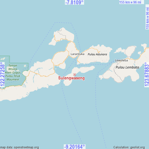
Sulengwaseng GPS coordinates[2]
8° 30' 24.84" South, 122° 58' 32.52" East
| Map corner | latitude | longitude |
|---|---|---|
| Upper-left | -7.8109°, | 122.27258° |
| Center: | -8.5069°, | 122.9757° |
| Lower-right: | -9.20164°, | 123.67883° |
| Map W x H: | 154.6×154.6 km | = 96.1×96.1mi |
| max Lat: | 5.88969° ⇑83.7% North |
| Sulengwaseng: | -8.5069° |
| min Lat: | ⇓16.3% South -10.934° |
| min Long | Sulengwaseng | max Long |
| 95.1345° | 122.9757° | 140.9419° |
| W 90%⇐ | ⇒10% E |
Elevation
Elevation of Sulengwaseng is 42 m = 138 ft, and this is 187.7 m = 616 ft below average elevation for this country.
| Max E: |
3185 m = 10449 ft | 65.2% |
| Avg. | 229.7 m = 754 ft | |
| Sulengwaseng | 42 m = 138 ft | |
Min E: |
-1 m = -3 ft | 34.8% |
See also: Indonesia elevation on elevation.city.
Geographical zone
Sulengwaseng is located in South Torrid zone (between Equator and Tropic of Capricorn). Distance of Equator is 945.9 km =587.8 mi to North.| Distance of | km | miles | from Sulengwaseng |
|---|---|---|---|
| Equator | 945.9 | 587.8 | to North |
| Tropic Capricorn | 1660 | 1031.5 | to South |
| Antarctic Circle | 6455.3 | 4011.1 | to South |
| South Pole | 9061.2 | 5630.4 | to South |


Nearby cities:
15 places around Sulengwaseng: (largest is in red/bold)
• Daniwato
3.4 km =2.1 mi,  307°
307°
• Haridimun
3.3 km =2.1 mi,  60°
60°
• Kalelu
5.7 km =3.5 mi,  227°
227°
• Karawatung
7.6 km =4.7 mi,  36°
36°
• Lamagohang
5.4 km =3.4 mi, 56°
• Lamalewo
6.5 km =4 mi,  347°
347°
• Lemboleng
11.2 km =7 mi,  79°
79°
• Lewograran
6.9 km =4.3 mi, 60°
• Ongalereng
7.8 km =4.8 mi,  27°
27°
• Pamakayo
7.8 km =4.8 mi,  5°
5°
• Rianglaka
4.6 km =2.9 mi,  329°
329°
• Ritaebang
10.5 km =6.5 mi,  255°
255°
• Ritaebang Satu
10.2 km =6.3 mi, 257°
• Tanahedang
9.5 km =5.9 mi,  237°
237°
• Wulublolong
10.5 km =6.5 mi, 44°
Sources, notices
• [Note1] Compared only with cities in Indonesia existing in our database
• [Src1] Map data: © OpenStreetMap contributors (CC-BY-SA)
• [Src2] Other city data from geonames.org with taken over terms of usage.
• [Src3] Geographical zone / Annual Mean Temperature by Robert A. Rohde @ Wikipedia
