Lamawai geodata
Lamawai (East Nusa Tenggara) is a seat of a fourth-order administrative division; located in Indonesia in Asia/Makassar (GMT+8) time zone. In our database, there are 407 cities with bigger population. Compared to other cities in Indonesia, 82.3% of cities are located further ↑North; 90.7% of cities are located further ←West and 81.9% of cities have higher elevation than Lamawai. Note1


Lamawai GPS coordinates[2]
8° 28' 11.64" South, 123° 6' 26.64" East
| Map corner | latitude | longitude |
|---|---|---|
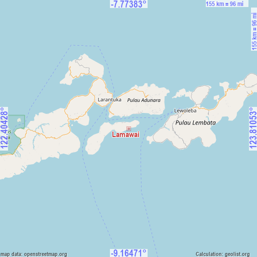
| Upper-left | -7.77383°, | 122.40428° |
| Center: | -8.4699°, | 123.1074° |
| Lower-right: | -9.16471°, | 123.81053° |
| Map W x H: | 154.7×154.7 km | = 96.1×96.1mi |
| max Lat: | 5.88969° ⇑82.3% North |
| Lamawai: | -8.4699° |
| min Lat: | ⇓17.7% South -10.934° |
| min Long | Lamawai | max Long |
| 95.1345° | 123.1074° | 140.9419° |
| W 90.7%⇐ | ⇒9.3% E |
Elevation
Elevation of Lamawai is 17 m = 56 ft, and this is 212.7 m = 698 ft below average elevation for this country.
| Max E: |
3185 m = 10449 ft | 81.9% |
| Avg. | 229.7 m = 754 ft | |
| Lamawai | 17 m = 56 ft | |
Min E: |
-1 m = -3 ft | 18.1% |
See also: Indonesia elevation on elevation.city.
Geographical zone
Lamawai is located in South Torrid zone (between Equator and Tropic of Capricorn). Distance of Equator is 941.8 km =585.2 mi to North.| Distance of | km | miles | from Lamawai |
|---|---|---|---|
| Equator | 941.8 | 585.2 | to North |
| Tropic Capricorn | 1664.2 | 1034.1 | to South |
| Antarctic Circle | 6459.4 | 4013.7 | to South |
| South Pole | 9065.3 | 5632.9 | to South |


Nearby cities:
15 places around Lamawai: (largest is in red/bold)
• Baniona
8.2 km =5.1 mi,  342°
342°
• Gorang
5.2 km =3.2 mi,  29°
29°
• Klukeng
8.5 km =5.3 mi, 343°
• Lamahala
10.1 km =6.3 mi, 28°
• Lamakera Dua
7.4 km =4.6 mi,  56°
56°
• Lamakera Satu
7.3 km =4.5 mi, 58°
• Lemboleng
4 km =2.5 mi,  240°
240°
• Lewograran
8.5 km =5.3 mi,  265°
265°
• Lohayong
5.8 km =3.6 mi,  312°
312°
• Menanga
4.4 km =2.7 mi,  328°
328°
• Mewet
7.9 km =4.9 mi,  352°
352°
• Terong
9.5 km =5.9 mi,  22°
22°
• Waiwukak
8.4 km =5.2 mi, 326°
• Watoona
2.2 km =1.4 mi, 241°
• Wulublolong
8 km =5 mi,  295°
295°
Sources, notices
• [Note1] Compared only with cities in Indonesia existing in our database
• [Src1] Map data: © OpenStreetMap contributors (CC-BY-SA)
• [Src2] Other city data from geonames.org with taken over terms of usage.
• [Src3] Geographical zone / Annual Mean Temperature by Robert A. Rohde @ Wikipedia
