Rundeng geodata
Rundeng (North Sumatra) is a seat of a third-order administrative division; located in Indonesia in Asia/Jakarta (GMT+7) time zone. In our database, there are 407 cities with bigger population. Compared to other cities in Indonesia, 97.7% of cities are located further ↓South; 98.6% of cities are located further →East and 74.1% of cities have higher elevation than Rundeng. Note1


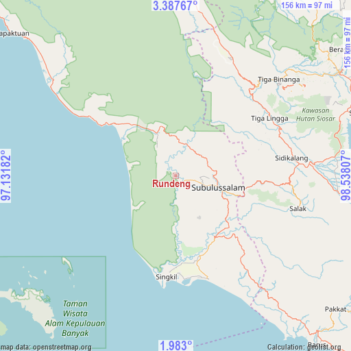
Rundeng GPS coordinates[2]
2° 41' 7.944" North, 97° 50' 5.784" East
| Map corner | latitude | longitude |
|---|---|---|
| Upper-left | 3.38767°, | 97.13182° |
| Center: | 2.68554°, | 97.83494° |
| Lower-right: | 1.983°, | 98.53807° |
| Map W x H: | 156.2×156.2 km | = 97.1×97.1mi |
| max Lat: | 5.88969° ⇑2.3% North |
| Rundeng: | 2.68554° |
| min Lat: | ⇓97.7% South -10.934° |
| min Long | Rundeng | max Long |
| 95.1345° | 97.83494° | 140.9419° |
| W 1.4%⇐ | ⇒98.6% E |
Elevation
Elevation of Rundeng is 26 m = 85 ft, and this is 203.7 m = 668 ft below average elevation for this country.
| Max E: |
3185 m = 10449 ft | 74.1% |
| Avg. | 229.7 m = 754 ft | |
| Rundeng | 26 m = 85 ft | |
Min E: |
-1 m = -3 ft | 25.9% |
See also: Indonesia elevation on elevation.city.
Geographical zone
Rundeng is located in North Torrid zone (between Equator and Tropic of Cancer). Distance of Equator is 298.6 km =185.5 mi to South.| Distance of | km | miles | from Rundeng |
|---|---|---|---|
| North Pole | 9708.5 | 6032.6 | to North |
| Arctic Circle | 7102.6 | 4413.3 | to North |
| Tropic Cancer | 2307.3 | 1433.7 | to North |
| Equator | 298.6 | 185.5 | to South |


Nearby cities:
15 places around Rundeng: (largest is in red/bold)
• Bakungan
47.2 km =29.3 mi,  304°
304°
• Danauparis
41.3 km =25.7 mi,  137°
137°
• Gosong Telaga
46.4 km =28.8 mi,  167°
167°
• Jambi Baru
12 km =7.5 mi,  29°
29°
• Krueng Luak
21 km =13 mi,  335°
335°
• Kuala Baru
49 km =30.4 mi,  186°
186°
• Kuala Baru Sungai
32.6 km =20.3 mi,  198°
198°
• Pasir Panjang
18.4 km =11.4 mi,  93°
93°
• Pulopaya
29.2 km =18.1 mi,  315°
315°
• Rimo
38.9 km =24.2 mi,  158°
158°
• Salak
56.1 km =34.9 mi,  104°
104°
• Sidikalang
53.5 km =33.2 mi,  82°
82°
• Singkil
44.6 km =27.7 mi, 186°
• Sukarama
52 km =32.3 mi, 94°
• Sumbul
62.8 km =39 mi, 84°
Sources, notices
• [Note1] Compared only with cities in Indonesia existing in our database
• [Src1] Map data: © OpenStreetMap contributors (CC-BY-SA)
• [Src2] Other city data from geonames.org with taken over terms of usage.
• [Src3] Geographical zone / Annual Mean Temperature by Robert A. Rohde @ Wikipedia
