Sukarama geodata
Sukarama (North Sumatra) is a seat of a third-order administrative division; located in Indonesia in Asia/Jakarta (GMT+7) time zone. In our database, there are 407 cities with bigger population. Compared to other cities in Indonesia, 97.6% of cities are located further ↓South; 98.3% of cities are located further →East and 94.9% of cities have lower elevation than Sukarama. Note1


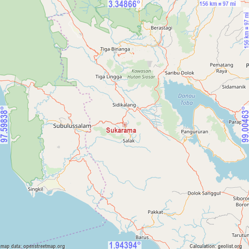
Sukarama GPS coordinates[2]
2° 38' 47.4" North, 98° 18' 5.4" East
| Map corner | latitude | longitude |
|---|---|---|
| Upper-left | 3.34866°, | 97.59838° |
| Center: | 2.6465°, | 98.3015° |
| Lower-right: | 1.94394°, | 99.00463° |
| Map W x H: | 156.2×156.2 km | = 97.1×97.1mi |
| max Lat: | 5.88969° ⇑2.4% North |
| Sukarama: | 2.6465° |
| min Lat: | ⇓97.6% South -10.934° |
| min Long | Sukarama | max Long |
| 95.1345° | 98.3015° | 140.9419° |
| W 1.7%⇐ | ⇒98.3% E |
Elevation
Elevation of Sukarama is 813 m = 2667 ft, and this is 583.3 m = 1914 ft above average elevation for this country.
| Max E: |
3185 m = 10449 ft | 5.1% |
| Sukarama | 813 m 2667 ft | |
| Avg. | 229.7 m = 754 ft | |
Min E: |
-1 m = -3 ft | 94.9% |
See also: Indonesia elevation on elevation.city.
Geographical zone
Sukarama is located in North Torrid zone (between Equator and Tropic of Cancer). Distance of Equator is 294.3 km =182.9 mi to South.| Distance of | km | miles | from Sukarama |
|---|---|---|---|
| North Pole | 9712.8 | 6035.3 | to North |
| Arctic Circle | 7106.9 | 4416 | to North |
| Tropic Cancer | 2311.7 | 1436.4 | to North |
| Equator | 294.3 | 182.9 | to South |


Nearby cities:
15 places around Sukarama: (largest is in red/bold)
• Danauparis
35.5 km =22.1 mi,  222°
222°
• Harian
41.3 km =25.7 mi,  104°
104°
• Jambi Baru
48.1 km =29.9 mi,  287°
287°
• Kabanjahe
54.6 km =33.9 mi,  22°
22°
• Pangururan
44 km =27.3 mi, 95°
• Parlilitan
39.8 km =24.7 mi,  154°
154°
• Pasir Panjang
33.6 km =20.9 mi,  275°
275°
• Rimo
49.5 km =30.8 mi,  229°
229°
• Rundeng
52 km =32.3 mi,  274°
274°
• Salak
10.3 km =6.4 mi,  166°
166°
• Saribudolok
47.3 km =29.4 mi,  46°
46°
• Sidikalang
11.5 km =7.1 mi,  6°
6°
• Sumbul
15 km =9.3 mi, 45°
• Tigarunggu
54.4 km =33.8 mi,  59°
59°
• Tongging
37.3 km =23.2 mi,  41°
41°
Sources, notices
• [Note1] Compared only with cities in Indonesia existing in our database
• [Src1] Map data: © OpenStreetMap contributors (CC-BY-SA)
• [Src2] Other city data from geonames.org with taken over terms of usage.
• [Src3] Geographical zone / Annual Mean Temperature by Robert A. Rohde @ Wikipedia
