Pulopaya geodata
Pulopaya (Aceh) is a seat of a third-order administrative division; located in Indonesia in Asia/Jakarta (GMT+7) time zone. In our database, there are 407 cities with bigger population. Compared to other cities in Indonesia, 97.9% of cities are located further ↓South; 98.7% of cities are located further →East and 90.6% of cities have higher elevation than Pulopaya. Note1


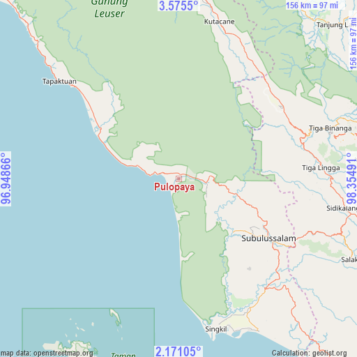
Pulopaya GPS coordinates[2]
2° 52' 24.564" North, 97° 39' 6.408" East
| Map corner | latitude | longitude |
|---|---|---|
| Upper-left | 3.5755°, | 96.94866° |
| Center: | 2.87349°, | 97.65178° |
| Lower-right: | 2.17105°, | 98.35491° |
| Map W x H: | 156.2×156.2 km | = 97.1×97.1mi |
| max Lat: | 5.88969° ⇑2.1% North |
| Pulopaya: | 2.87349° |
| min Lat: | ⇓97.9% South -10.934° |
| min Long | Pulopaya | max Long |
| 95.1345° | 97.65178° | 140.9419° |
| W 1.3%⇐ | ⇒98.7% E |
Elevation
Elevation of Pulopaya is 10 m = 33 ft, and this is 219.7 m = 721 ft below average elevation for this country.
| Max E: |
3185 m = 10449 ft | 90.6% |
| Avg. | 229.7 m = 754 ft | |
| Pulopaya | 10 m = 33 ft | |
Min E: |
-1 m = -3 ft | 9.4% |
See also: Indonesia elevation on elevation.city.
Geographical zone
Pulopaya is located in North Torrid zone (between Equator and Tropic of Cancer). Distance of Equator is 319.5 km =198.5 mi to South.| Distance of | km | miles | from Pulopaya |
|---|---|---|---|
| North Pole | 9687.6 | 6019.6 | to North |
| Arctic Circle | 7081.7 | 4400.4 | to North |
| Tropic Cancer | 2286.4 | 1420.7 | to North |
| Equator | 319.5 | 198.5 | to South |


Nearby cities:
15 places around Pulopaya: (largest is in red/bold)
• Bakungan
19.6 km =12.2 mi,  286°
286°
• Jambi Baru
28.3 km =17.6 mi,  111°
111°
• Krueng Luak
11.9 km =7.4 mi,  98°
98°
• Kuala Baru Sungai
52.7 km =32.7 mi,  169°
169°
• Lawepakam
59.4 km =36.9 mi,  36°
36°
• Lawesigalagala Timur
60.3 km =37.5 mi,  32°
32°
• Ngkan
58.8 km =36.5 mi,  1°
1°
• Pasir Panjang
44.6 km =27.7 mi,  119°
119°
• Paya Dapur
45.5 km =28.3 mi,  325°
325°
• Pulo Ie
56.1 km =34.9 mi,  324°
324°
• Rimo
66.7 km =41.4 mi,  149°
149°
• Rundeng
29.2 km =18.1 mi,  135°
135°
• Singkil
66.9 km =41.6 mi, 166°
• Suak Bakung
35.1 km =21.8 mi, 294°
• Terbangan
56.8 km =35.3 mi,  312°
312°
Sources, notices
• [Note1] Compared only with cities in Indonesia existing in our database
• [Src1] Map data: © OpenStreetMap contributors (CC-BY-SA)
• [Src2] Other city data from geonames.org with taken over terms of usage.
• [Src3] Geographical zone / Annual Mean Temperature by Robert A. Rohde @ Wikipedia
