Nyalindung geodata
Nyalindung (West Java) is a seat of a third-order administrative division; located in Indonesia in Asia/Jakarta (GMT+7) time zone. In our database, there are 407 cities with bigger population. Compared to other cities in Indonesia, 63.1% of cities are located further ↓South; 85.8% of cities are located further →East and 96.6% of cities have lower elevation than Nyalindung. Note1


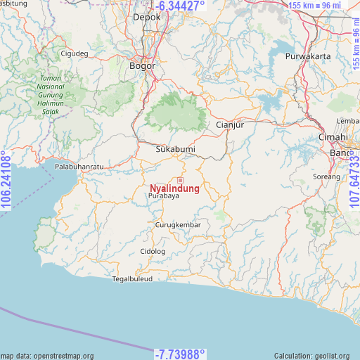
Nyalindung GPS coordinates[2]
7° 2' 33.36" South, 106° 56' 39.12" East
| Map corner | latitude | longitude |
|---|---|---|
| Upper-left | -6.34427°, | 106.24108° |
| Center: | -7.0426°, | 106.9442° |
| Lower-right: | -7.73988°, | 107.64733° |
| Map W x H: | 155.2×155.2 km | = 96.4×96.4mi |
| max Lat: | 5.88969° ⇑36.9% North |
| Nyalindung: | -7.0426° |
| min Lat: | ⇓63.1% South -10.934° |
| min Long | Nyalindung | max Long |
| 95.1345° | 106.9442° | 140.9419° |
| W 14.2%⇐ | ⇒85.8% E |
Elevation
Elevation of Nyalindung is 920 m = 3018 ft, and this is 690.3 m = 2265 ft above average elevation for this country.
| Max E: |
3185 m = 10449 ft | 3.4% |
| Nyalindung | 920 m 3018 ft | |
| Avg. | 229.7 m = 754 ft | |
Min E: |
-1 m = -3 ft | 96.6% |
See also: Indonesia elevation on elevation.city.
Geographical zone
Nyalindung is located in South Torrid zone (between Equator and Tropic of Capricorn). Distance of Equator is 783.1 km =486.6 mi to North.| Distance of | km | miles | from Nyalindung |
|---|---|---|---|
| Equator | 783.1 | 486.6 | to North |
| Tropic Capricorn | 1822.9 | 1132.7 | to South |
| Antarctic Circle | 6618.1 | 4112.3 | to South |
| South Pole | 9224 | 5731.5 | to South |


Nearby cities:
15 places around Nyalindung: (largest is in red/bold)
• Bungbangsari
4.6 km =2.9 mi,  122°
122°
• Cibiru
6.7 km =4.2 mi,  201°
201°
• Cigawir
6.5 km =4 mi,  231°
231°
• Cipesing
5.7 km =3.5 mi,  254°
254°
• Cisantri
3.6 km =2.2 mi, 234°
• Legok
2.9 km =1.8 mi,  24°
24°
• Liunggunung
1.5 km =0.9 mi,  326°
326°
• Mekarjaya
9.1 km =5.7 mi,  77°
77°
• Pasirawi
6.1 km =3.8 mi,  171°
171°
• Pasirhuni
5.2 km =3.2 mi,  69°
69°
• Pasirreungit
8.1 km =5 mi,  63°
63°
• Sindangraja
7.3 km =4.5 mi,  189°
189°
• Sukamaju
7.6 km =4.7 mi,  303°
303°
• Takokak
6.6 km =4.1 mi,  98°
98°
• Tanahbeureum
7.5 km =4.7 mi,  162°
162°
Sources, notices
• [Note1] Compared only with cities in Indonesia existing in our database
• [Src1] Map data: © OpenStreetMap contributors (CC-BY-SA)
• [Src2] Other city data from geonames.org with taken over terms of usage.
• [Src3] Geographical zone / Annual Mean Temperature by Robert A. Rohde @ Wikipedia
