Munjul geodata
Munjul (West Java) is a seat of a fourth-order administrative division; located in Indonesia in Asia/Jakarta (GMT+7) time zone. In our database, there are 407 cities with bigger population. Compared to other cities in Indonesia, 53.2% of cities are located further ↓South; 82.4% of cities are located further →East and 95.4% of cities have lower elevation than Munjul. Note1


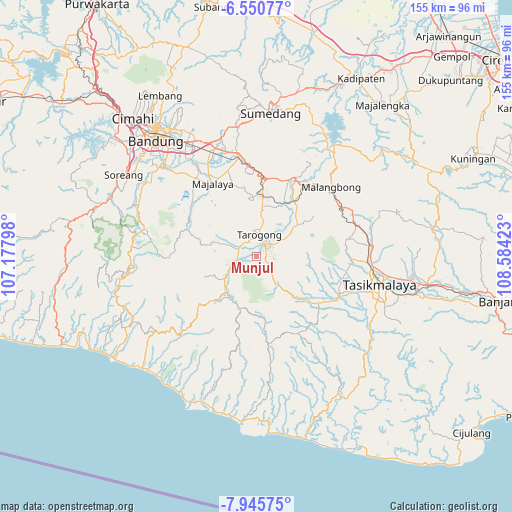
Munjul GPS coordinates[2]
7° 14' 55.68" South, 107° 52' 51.96" East
| Map corner | latitude | longitude |
|---|---|---|
| Upper-left | -6.55077°, | 107.17798° |
| Center: | -7.2488°, | 107.8811° |
| Lower-right: | -7.94575°, | 108.58423° |
| Map W x H: | 155.1×155.1 km | = 96.4×96.4mi |
| max Lat: | 5.88969° ⇑46.8% North |
| Munjul: | -7.2488° |
| min Lat: | ⇓53.2% South -10.934° |
| min Long | Munjul | max Long |
| 95.1345° | 107.8811° | 140.9419° |
| W 17.6%⇐ | ⇒82.4% E |
Elevation
Elevation of Munjul is 838 m = 2749 ft, and this is 608.3 m = 1996 ft above average elevation for this country.
| Max E: |
3185 m = 10449 ft | 4.6% |
| Munjul | 838 m 2749 ft | |
| Avg. | 229.7 m = 754 ft | |
Min E: |
-1 m = -3 ft | 95.4% |
See also: Indonesia elevation on elevation.city.
Geographical zone
Munjul is located in South Torrid zone (between Equator and Tropic of Capricorn). Distance of Equator is 806 km =500.8 mi to North.| Distance of | km | miles | from Munjul |
|---|---|---|---|
| Equator | 806 | 500.8 | to North |
| Tropic Capricorn | 1799.9 | 1118.4 | to South |
| Antarctic Circle | 6595.2 | 4098.1 | to South |
| South Pole | 9201.1 | 5717.3 | to South |


Nearby cities:
15 places around Munjul: (largest is in red/bold)
• Babakan Sukasari
2.3 km =1.4 mi,  175°
175°
• Bangbayang
2.7 km =1.7 mi,  230°
230°
• Bebedahan
1.4 km =0.9 mi,  210°
210°
• Besarmanah
2.9 km =1.8 mi,  23°
23°
• Cangkuang
3.2 km =2 mi,  43°
43°
• Cibunar
1.5 km =0.9 mi,  28°
28°
• Cimacan
3 km =1.9 mi,  237°
237°
• Cimaragas
3.1 km =1.9 mi,  81°
81°
• Cimaung Kidul
2.3 km =1.4 mi,  125°
125°
• Desakolot
1.5 km =0.9 mi,  122°
122°
• Gudang
3.2 km =2 mi,  245°
245°
• Kondangrege
2.8 km =1.7 mi,  159°
159°
• Ngamplang
2.2 km =1.4 mi,  106°
106°
• Panunggangan
2.5 km =1.6 mi, 16°
• Salakuray
2 km =1.2 mi, 245°
Sources, notices
• [Note1] Compared only with cities in Indonesia existing in our database
• [Src1] Map data: © OpenStreetMap contributors (CC-BY-SA)
• [Src2] Other city data from geonames.org with taken over terms of usage.
• [Src3] Geographical zone / Annual Mean Temperature by Robert A. Rohde @ Wikipedia
