Cimaung Kidul geodata
Cimaung Kidul (West Java) is a seat of a fourth-order administrative division; located in Indonesia in Asia/Jakarta (GMT+7) time zone. In our database, there are 407 cities with bigger population. Compared to other cities in Indonesia, 52.7% of cities are located further ↓South; 82% of cities are located further →East and 96.2% of cities have lower elevation than Cimaung Kidul. Note1


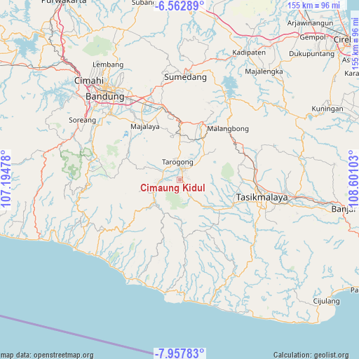
Cimaung Kidul GPS coordinates[2]
7° 15' 39.24" South, 107° 53' 52.44" East
| Map corner | latitude | longitude |
|---|---|---|
| Upper-left | -6.56289°, | 107.19478° |
| Center: | -7.2609°, | 107.8979° |
| Lower-right: | -7.95783°, | 108.60103° |
| Map W x H: | 155.1×155.1 km | = 96.4×96.4mi |
| max Lat: | 5.88969° ⇑47.3% North |
| Cimaung Kidul: | -7.2609° |
| min Lat: | ⇓52.7% South -10.934° |
| min Long | Cimaung Kidul | max Long |
| 95.1345° | 107.8979° | 140.9419° |
| W 18%⇐ | ⇒82% E |
Elevation
Elevation of Cimaung Kidul is 891 m = 2923 ft, and this is 661.3 m = 2170 ft above average elevation for this country.
| Max E: |
3185 m = 10449 ft | 3.8% |
| Cimaung Kidul | 891 m 2923 ft | |
| Avg. | 229.7 m = 754 ft | |
Min E: |
-1 m = -3 ft | 96.2% |
See also: Indonesia elevation on elevation.city.
Geographical zone
Cimaung Kidul is located in South Torrid zone (between Equator and Tropic of Capricorn). Distance of Equator is 807.3 km =501.6 mi to North.| Distance of | km | miles | from Cimaung Kidul |
|---|---|---|---|
| Equator | 807.3 | 501.6 | to North |
| Tropic Capricorn | 1798.6 | 1117.6 | to South |
| Antarctic Circle | 6593.8 | 4097.2 | to South |
| South Pole | 9199.7 | 5716.4 | to South |


Nearby cities:
15 places around Cimaung Kidul: (largest is in red/bold)
• Babakan Baru
3.4 km =2.1 mi,  72°
72°
• Babakan Sukasari
1.9 km =1.2 mi,  239°
239°
• Bebedahan
2.6 km =1.6 mi,  272°
272°
• Cibunar
2.9 km =1.8 mi,  337°
337°
• Cigadog
3.5 km =2.2 mi,  132°
132°
• Cikuwiwi
2.1 km =1.3 mi,  192°
192°
• Cilawu
3.1 km =1.9 mi, 127°
• Cimaragas
2.1 km =1.3 mi,  32°
32°
• Desakolot
0.8 km =0.5 mi,  314°
314°
• Gugunungan
3.3 km =2.1 mi, 29°
• Kondangrege
1.5 km =0.9 mi,  214°
214°
• Munjul
2.3 km =1.4 mi, 305°
• Ngamplang
0.8 km =0.5 mi,  16°
16°
• Pasanggrahan
1.6 km =1 mi,  103°
103°
• Pasirlimus
1.9 km =1.2 mi,  174°
174°
Sources, notices
• [Note1] Compared only with cities in Indonesia existing in our database
• [Src1] Map data: © OpenStreetMap contributors (CC-BY-SA)
• [Src2] Other city data from geonames.org with taken over terms of usage.
• [Src3] Geographical zone / Annual Mean Temperature by Robert A. Rohde @ Wikipedia
