Sobo geodata
Sobo (East Java) is a seat of a fourth-order administrative division; located in Indonesia in Asia/Jakarta (GMT+7) time zone. In our database, there are 407 cities with bigger population. Compared to other cities in Indonesia, 75.8% of cities are located further ↑North; 57.6% of cities are located further →East and 77.7% of cities have lower elevation than Sobo. Note1


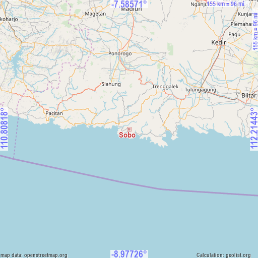
Sobo GPS coordinates[2]
8° 16' 55.56" South, 111° 30' 40.68" East
| Map corner | latitude | longitude |
|---|---|---|
| Upper-left | -7.58571°, | 110.80818° |
| Center: | -8.2821°, | 111.5113° |
| Lower-right: | -8.97726°, | 112.21443° |
| Map W x H: | 154.7×154.7 km | = 96.1×96.1mi |
| max Lat: | 5.88969° ⇑75.8% North |
| Sobo: | -8.2821° |
| min Lat: | ⇓24.2% South -10.934° |
| min Long | Sobo | max Long |
| 95.1345° | 111.5113° | 140.9419° |
| W 42.4%⇐ | ⇒57.6% E |
Elevation
Elevation of Sobo is 393 m = 1289 ft, and this is 163.3 m = 536 ft above average elevation for this country.
| Max E: |
3185 m = 10449 ft | 22.3% |
| Sobo | 393 m 1289 ft | |
| Avg. | 229.7 m = 754 ft | |
Min E: |
-1 m = -3 ft | 77.7% |
See also: Indonesia elevation on elevation.city.
Geographical zone
Sobo is located in South Torrid zone (between Equator and Tropic of Capricorn). Distance of Equator is 920.9 km =572.2 mi to North.| Distance of | km | miles | from Sobo |
|---|---|---|---|
| Equator | 920.9 | 572.2 | to North |
| Tropic Capricorn | 1685 | 1047 | to South |
| Antarctic Circle | 6480.3 | 4026.7 | to South |
| South Pole | 9086.2 | 5645.9 | to South |


Nearby cities:
15 places around Sobo: (largest is in red/bold)
• Banjar
3.8 km =2.4 mi,  295°
295°
• Karangsudo
6.8 km =4.2 mi,  16°
16°
• Karangturi
7.7 km =4.8 mi,  86°
86°
• Krajan Craken
3.9 km =2.4 mi,  113°
113°
• Krajan Ngrambingan
3.5 km =2.2 mi,  315°
315°
• Masaran
5.9 km =3.7 mi, 114°
• Munjungan
7.8 km =4.8 mi, 107°
• Nglebeng
6.9 km =4.3 mi,  294°
294°
• Ngrencak
7.1 km =4.4 mi,  313°
313°
• Ngulung Kulon
2.5 km =1.6 mi,  190°
190°
• Ngulung Wetan
3 km =1.9 mi,  246°
246°
• Pandean
5.5 km =3.4 mi,  28°
28°
• Panggul
7.2 km =4.5 mi, 300°
• Watuagung
3.4 km =2.1 mi,  10°
10°
• Wonocoyo Utara
7.2 km =4.5 mi, 298°
Sources, notices
• [Note1] Compared only with cities in Indonesia existing in our database
• [Src1] Map data: © OpenStreetMap contributors (CC-BY-SA)
• [Src2] Other city data from geonames.org with taken over terms of usage.
• [Src3] Geographical zone / Annual Mean Temperature by Robert A. Rohde @ Wikipedia
