Munjungan geodata
Munjungan (East Java) is a seat of a third-order administrative division; located in Indonesia in Asia/Jakarta (GMT+7) time zone. In our database, there are 407 cities with bigger population. Compared to other cities in Indonesia, 76.8% of cities are located further ↑North; 56.6% of cities are located further →East and 89% of cities have higher elevation than Munjungan. Note1


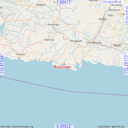
Munjungan GPS coordinates[2]
8° 18' 11.16" South, 111° 34' 42.96" East
| Map corner | latitude | longitude |
|---|---|---|
| Upper-left | -7.60675°, | 110.87548° |
| Center: | -8.3031°, | 111.5786° |
| Lower-right: | -8.99822°, | 112.28173° |
| Map W x H: | 154.7×154.7 km | = 96.1×96.1mi |
| max Lat: | 5.88969° ⇑76.8% North |
| Munjungan: | -8.3031° |
| min Lat: | ⇓23.2% South -10.934° |
| min Long | Munjungan | max Long |
| 95.1345° | 111.5786° | 140.9419° |
| W 43.4%⇐ | ⇒56.6% E |
Elevation
Elevation of Munjungan is 11 m = 36 ft, and this is 218.7 m = 718 ft below average elevation for this country.
| Max E: |
3185 m = 10449 ft | 89% |
| Avg. | 229.7 m = 754 ft | |
| Munjungan | 11 m = 36 ft | |
Min E: |
-1 m = -3 ft | 11% |
See also: Indonesia elevation on elevation.city.
Geographical zone
Munjungan is located in South Torrid zone (between Equator and Tropic of Capricorn). Distance of Equator is 923.2 km =573.6 mi to North.| Distance of | km | miles | from Munjungan |
|---|---|---|---|
| Equator | 923.2 | 573.6 | to North |
| Tropic Capricorn | 1682.7 | 1045.6 | to South |
| Antarctic Circle | 6478 | 4025.2 | to South |
| South Pole | 9083.8 | 5644.4 | to South |


Nearby cities:
15 places around Munjungan: (largest is in red/bold)
• Bendoroto
3.5 km =2.2 mi,  98°
98°
• Besuki
4.9 km =3 mi,  20°
20°
• Jajar
5.7 km =3.5 mi,  78°
78°
• Karangsudo
10.4 km =6.5 mi,  328°
328°
• Karangturi
2.8 km =1.7 mi,  5°
5°
• Krajan Craken
3.9 km =2.4 mi,  281°
281°
• Krajan Ngrambingan
11 km =6.8 mi,  296°
296°
• Masaran
2 km =1.2 mi,  267°
267°
• Ngulung Kulon
7.9 km =4.9 mi, 268°
• Ngulung Wetan
10.2 km =6.3 mi, 276°
• Pandean
8.6 km =5.3 mi, 325°
• Salamwates
8.7 km =5.4 mi,  350°
350°
• Sobo
7.8 km =4.8 mi,  287°
287°
• Tawing
1.9 km =1.2 mi, 101°
• Watuagung
8.8 km =5.5 mi,  310°
310°
Sources, notices
• [Note1] Compared only with cities in Indonesia existing in our database
• [Src1] Map data: © OpenStreetMap contributors (CC-BY-SA)
• [Src2] Other city data from geonames.org with taken over terms of usage.
• [Src3] Geographical zone / Annual Mean Temperature by Robert A. Rohde @ Wikipedia
