Kota Binjai geodata
Kota Binjai (Aceh) is a seat of a third-order administrative division; located in Indonesia in Asia/Jakarta (GMT+7) time zone. In our database, there are 407 cities with bigger population. Compared to other cities in Indonesia, 99.5% of cities are located further ↓South; 98.7% of cities are located further →East and 98.5% of cities have higher elevation than Kota Binjai. Note1


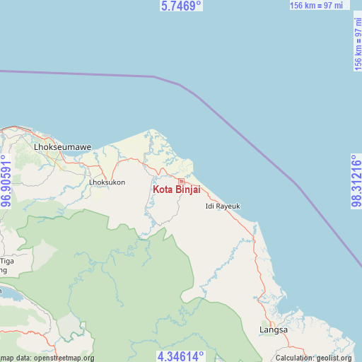
Kota Binjai GPS coordinates[2]
5° 2' 48.84" North, 97° 36' 32.508" East
| Map corner | latitude | longitude |
|---|---|---|
| Upper-left | 5.7469°, | 96.90591° |
| Center: | 5.0469°, | 97.60903° |
| Lower-right: | 4.34614°, | 98.31216° |
| Map W x H: | 155.7×155.8 km | = 96.7×96.8mi |
| max Lat: | 5.88969° ⇑0.5% North |
| Kota Binjai: | 5.0469° |
| min Lat: | ⇓99.5% South -10.934° |
| min Long | Kota Binjai | max Long |
| 95.1345° | 97.60903° | 140.9419° |
| W 1.3%⇐ | ⇒98.7% E |
Elevation
Elevation of Kota Binjai is 5 m = 16 ft, and this is 224.7 m = 737 ft below average elevation for this country.
| Max E: |
3185 m = 10449 ft | 98.5% |
| Avg. | 229.7 m = 754 ft | |
| Kota Binjai | 5 m = 16 ft | |
Min E: |
-1 m = -3 ft | 1.5% |
See also: Indonesia elevation on elevation.city.
Geographical zone
Kota Binjai is located in North Torrid zone (between Equator and Tropic of Cancer). Distance of Equator is 561.2 km =348.7 mi to South.| Distance of | km | miles | from Kota Binjai |
|---|---|---|---|
| North Pole | 9445.9 | 5869.4 | to North |
| Arctic Circle | 6840 | 4250.2 | to North |
| Tropic Cancer | 2044.8 | 1270.6 | to North |
| Equator | 561.2 | 348.7 | to South |


Nearby cities:
15 places around Kota Binjai: (largest is in red/bold)
• Bagok
12.7 km =7.9 mi,  150°
150°
• Beusa Seberang
33.5 km =20.8 mi,  125°
125°
• Buket Teukuh
27 km =16.8 mi,  168°
168°
• Idi Cut
15.6 km =9.7 mi,  119°
119°
• Idi Rayeuk
24 km =14.9 mi, 122°
• Lhokseumawe
52.9 km =32.9 mi,  286°
286°
• Matangkuli
36.1 km =22.4 mi,  267°
267°
• Matangpayang
40.8 km =25.4 mi,  282°
282°
• Penaron
45.9 km =28.5 mi, 169°
• Peureulak
40.8 km =25.4 mi, 130°
• Rantau Panjang
39.2 km =24.4 mi,  155°
155°
• Seuneubok Bayu
19.2 km =11.9 mi,  191°
191°
• Seunudon
25.3 km =15.7 mi,  315°
315°
• Simpang Ulim
9.8 km =6.1 mi,  328°
328°
• Sungai Raya
46.2 km =28.7 mi, 133°
Sources, notices
• [Note1] Compared only with cities in Indonesia existing in our database
• [Src1] Map data: © OpenStreetMap contributors (CC-BY-SA)
• [Src2] Other city data from geonames.org with taken over terms of usage.
• [Src3] Geographical zone / Annual Mean Temperature by Robert A. Rohde @ Wikipedia
