Lhokseumawe geodata
Lhokseumawe (Aceh) is a populated place; located in Indonesia in Asia/Jakarta (GMT+7) time zone. With population of 88,974 people, there are 147 cities with bigger population in this country. Compared to other cities in Indonesia, 99.6% of cities are located further ↓South; 99% of cities are located further →East and 97.2% of cities have higher elevation than Lhokseumawe. Note1


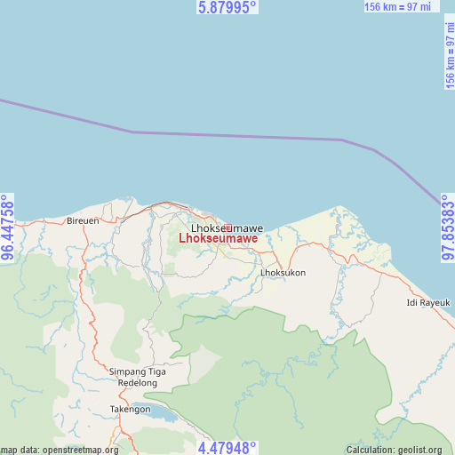
Lhokseumawe GPS coordinates[2]
5° 10' 48.36" North, 97° 9' 2.52" East
| Map corner | latitude | longitude |
|---|---|---|
| Upper-left | 5.87995°, | 96.44758° |
| Center: | 5.1801°, | 97.1507° |
| Lower-right: | 4.47948°, | 97.85383° |
| Map W x H: | 155.7×155.7 km | = 96.7×96.7mi |
| max Lat: | 5.88969° ⇑0.4% North |
| Lhokseumawe: | 5.1801° |
| min Lat: | ⇓99.6% South -10.934° |
| min Long | Lhokseumawe | max Long |
| 95.1345° | 97.1507° | 140.9419° |
| W 1%⇐ | ⇒99% E |
Elevation
Elevation of Lhokseumawe is 6 m = 20 ft, and this is 223.7 m = 734 ft below average elevation for this country.
| Max E: |
3185 m = 10449 ft | 97.2% |
| Avg. | 229.7 m = 754 ft | |
| Lhokseumawe | 6 m = 20 ft | |
Min E: |
-1 m = -3 ft | 2.8% |
See also: Lhokseumawe elevation on elevation.city.
Geographical zone
Lhokseumawe is located in North Torrid zone (between Equator and Tropic of Cancer). Distance of Equator is 576 km =357.9 mi to South.| Distance of | km | miles | from Lhokseumawe |
|---|---|---|---|
| North Pole | 9431.1 | 5860.2 | to North |
| Arctic Circle | 6825.2 | 4241 | to North |
| Tropic Cancer | 2029.9 | 1261.3 | to North |
| Equator | 576 | 357.9 | to South |


Nearby cities:
15 places around Lhokseumawe: (largest is in red/bold)
• Adil Makmur
31.1 km =19.3 mi,  273°
273°
• Alue Glumpang
44.2 km =27.5 mi,  255°
255°
• Bireun
49.9 km =31 mi, 272°
• Blang Ara
15.5 km =9.6 mi,  240°
240°
• Blang Mane
45.7 km =28.4 mi,  246°
246°
• Blangpulo
8.6 km =5.3 mi,  290°
290°
• Bulahblangaro
34.6 km =21.5 mi, 252°
• Cot Baroh
34.5 km =21.4 mi,  276°
276°
• Juli
49.4 km =30.7 mi, 260°
• Jumpangdua
40.6 km =25.2 mi, 272°
• Kota Binjai
52.9 km =32.9 mi,  106°
106°
• Matangkuli
22.1 km =13.7 mi,  138°
138°
• Matangpayang
12.5 km =7.8 mi,  118°
118°
• Seunudon
33.2 km =20.6 mi,  84°
84°
• Simpang Ulim
46 km =28.6 mi,  98°
98°
Sources, notices
• [Note1] Compared only with cities in Indonesia existing in our database
• [Src1] Map data: © OpenStreetMap contributors (CC-BY-SA)
• [Src2] Other city data from geonames.org with taken over terms of usage.
• [Src3] Geographical zone / Annual Mean Temperature by Robert A. Rohde @ Wikipedia
