Sungaitabuk geodata
Sungaitabuk (South Kalimantan) is a seat of a third-order administrative division; located in Indonesia in Asia/Makassar (GMT+8) time zone. In our database, there are 407 cities with bigger population. Compared to other cities in Indonesia, 90.8% of cities are located further ↓South; 70.2% of cities are located further ←West and 98.5% of cities have higher elevation than Sungaitabuk. Note1


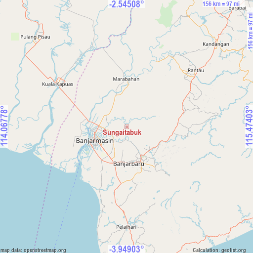
Sungaitabuk GPS coordinates[2]
3° 14' 50.28" South, 114° 46' 15.24" East
| Map corner | latitude | longitude |
|---|---|---|
| Upper-left | -2.54508°, | 114.06778° |
| Center: | -3.2473°, | 114.7709° |
| Lower-right: | -3.94903°, | 115.47403° |
| Map W x H: | 156.1×156.1 km | = 97×97mi |
| max Lat: | 5.88969° ⇑9.2% North |
| Sungaitabuk: | -3.2473° |
| min Lat: | ⇓90.8% South -10.934° |
| min Long | Sungaitabuk | max Long |
| 95.1345° | 114.7709° | 140.9419° |
| W 70.2%⇐ | ⇒29.8% E |
Elevation
Elevation of Sungaitabuk is 5 m = 16 ft, and this is 224.7 m = 737 ft below average elevation for this country.
| Max E: |
3185 m = 10449 ft | 98.5% |
| Avg. | 229.7 m = 754 ft | |
| Sungaitabuk | 5 m = 16 ft | |
Min E: |
-1 m = -3 ft | 1.5% |
See also: Indonesia elevation on elevation.city.
Geographical zone
Sungaitabuk is located in South Torrid zone (between Equator and Tropic of Capricorn). Distance of Equator is 361.1 km =224.4 mi to North.| Distance of | km | miles | from Sungaitabuk |
|---|---|---|---|
| Equator | 361.1 | 224.4 | to North |
| Tropic Capricorn | 2244.9 | 1394.9 | to South |
| Antarctic Circle | 7040.1 | 4374.5 | to South |
| South Pole | 9646 | 5993.7 | to South |


Nearby cities:
15 places around Sungaitabuk: (largest is in red/bold)
• Aluhaluh
37.6 km =23.4 mi,  221°
221°
• Anjirmuara
23.3 km =14.5 mi,  283°
283°
• Astambul
20.9 km =13 mi,  130°
130°
• Banjarmasin
21.6 km =13.4 mi,  248°
248°
• Bantul
22.7 km =14.1 mi,  357°
357°
• Belawang
23.1 km =14.4 mi,  327°
327°
• Gambut
19.7 km =12.2 mi,  212°
212°
• Karangintan
32.5 km =20.2 mi,  124°
124°
• Marabahan
26 km =16.2 mi, 359°
• Martapura
20.9 km =13 mi,  150°
150°
• Simpangempat
28.9 km =18 mi,  96°
96°
• Sungaigampa
19.7 km =12.2 mi,  336°
336°
• Sungaipuntik
13.1 km =8.1 mi,  311°
311°
• Sungairaya
32 km =19.9 mi, 97°
• Tabunganen
36.7 km =22.8 mi,  240°
240°
Sources, notices
• [Note1] Compared only with cities in Indonesia existing in our database
• [Src1] Map data: © OpenStreetMap contributors (CC-BY-SA)
• [Src2] Other city data from geonames.org with taken over terms of usage.
• [Src3] Geographical zone / Annual Mean Temperature by Robert A. Rohde @ Wikipedia
