Astambul geodata
Astambul (South Kalimantan) is a seat of a third-order administrative division; located in Indonesia in Asia/Makassar (GMT+8) time zone. In our database, there are 407 cities with bigger population. Compared to other cities in Indonesia, 90.6% of cities are located further ↓South; 70.4% of cities are located further ←West and 86.4% of cities have higher elevation than Astambul. Note1


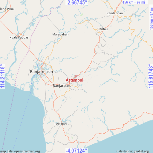
Astambul GPS coordinates[2]
3° 22' 10.56" South, 114° 54' 51.48" East
| Map corner | latitude | longitude |
|---|---|---|
| Upper-left | -2.66745°, | 114.21118° |
| Center: | -3.3696°, | 114.9143° |
| Lower-right: | -4.07124°, | 115.61743° |
| Map W x H: | 156.1×156.1 km | = 97×97mi |
| max Lat: | 5.88969° ⇑9.4% North |
| Astambul: | -3.3696° |
| min Lat: | ⇓90.6% South -10.934° |
| min Long | Astambul | max Long |
| 95.1345° | 114.9143° | 140.9419° |
| W 70.4%⇐ | ⇒29.6% E |
Elevation
Elevation of Astambul is 13 m = 43 ft, and this is 216.7 m = 711 ft below average elevation for this country.
| Max E: |
3185 m = 10449 ft | 86.4% |
| Avg. | 229.7 m = 754 ft | |
| Astambul | 13 m = 43 ft | |
Min E: |
-1 m = -3 ft | 13.6% |
See also: Indonesia elevation on elevation.city.
Geographical zone
Astambul is located in South Torrid zone (between Equator and Tropic of Capricorn). Distance of Equator is 374.7 km =232.8 mi to North.| Distance of | km | miles | from Astambul |
|---|---|---|---|
| Equator | 374.7 | 232.8 | to North |
| Tropic Capricorn | 2231.3 | 1386.5 | to South |
| Antarctic Circle | 7026.5 | 4366.1 | to South |
| South Pole | 9632.4 | 5985.3 | to South |


Nearby cities:
15 places around Astambul: (largest is in red/bold)
• Anjirmuara
43.1 km =26.8 mi,  296°
296°
• Banjarmasin
36.3 km =22.6 mi,  278°
278°
• Bantul
40.1 km =24.9 mi,  334°
334°
• Batibati
35.3 km =21.9 mi,  218°
218°
• Gambut
26.7 km =16.6 mi,  263°
263°
• Karangintan
11.9 km =7.4 mi,  113°
113°
• Kurau
43.1 km =26.8 mi,  239°
239°
• Marabahan
42.8 km =26.6 mi,  337°
337°
• Martapura
7.2 km =4.5 mi,  230°
230°
• Pangaron
32 km =19.9 mi,  78°
78°
• Simpangempat
16.3 km =10.1 mi,  51°
51°
• Sungaigampa
39.6 km =24.6 mi,  323°
323°
• Sungaipuntik
34 km =21.1 mi,  310°
310°
• Sungairaya
18.3 km =11.4 mi,  59°
59°
• Sungaitabuk
20.9 km =13 mi, 310°
Sources, notices
• [Note1] Compared only with cities in Indonesia existing in our database
• [Src1] Map data: © OpenStreetMap contributors (CC-BY-SA)
• [Src2] Other city data from geonames.org with taken over terms of usage.
• [Src3] Geographical zone / Annual Mean Temperature by Robert A. Rohde @ Wikipedia
