Sungaigampa geodata
Sungaigampa (South Kalimantan) is a seat of a third-order administrative division; located in Indonesia in Asia/Makassar (GMT+8) time zone. In our database, there are 407 cities with bigger population. Compared to other cities in Indonesia, 91.1% of cities are located further ↓South; 70.1% of cities are located further ←West and 97.2% of cities have higher elevation than Sungaigampa. Note1


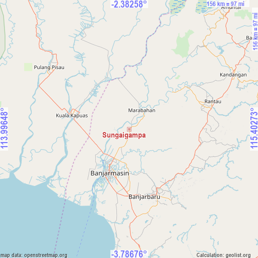
Sungaigampa GPS coordinates[2]
3° 5' 5.64" South, 114° 41' 58.56" East
| Map corner | latitude | longitude |
|---|---|---|
| Upper-left | -2.38258°, | 113.99648° |
| Center: | -3.0849°, | 114.6996° |
| Lower-right: | -3.78676°, | 115.40273° |
| Map W x H: | 156.1×156.1 km | = 97×97mi |
| max Lat: | 5.88969° ⇑8.9% North |
| Sungaigampa: | -3.0849° |
| min Lat: | ⇓91.1% South -10.934° |
| min Long | Sungaigampa | max Long |
| 95.1345° | 114.6996° | 140.9419° |
| W 70.1%⇐ | ⇒29.9% E |
Elevation
Elevation of Sungaigampa is 6 m = 20 ft, and this is 223.7 m = 734 ft below average elevation for this country.
| Max E: |
3185 m = 10449 ft | 97.2% |
| Avg. | 229.7 m = 754 ft | |
| Sungaigampa | 6 m = 20 ft | |
Min E: |
-1 m = -3 ft | 2.8% |
See also: Indonesia elevation on elevation.city.
Geographical zone
Sungaigampa is located in South Torrid zone (between Equator and Tropic of Capricorn). Distance of Equator is 343 km =213.1 mi to North.| Distance of | km | miles | from Sungaigampa |
|---|---|---|---|
| Equator | 343 | 213.1 | to North |
| Tropic Capricorn | 2262.9 | 1406.1 | to South |
| Antarctic Circle | 7058.2 | 4385.8 | to South |
| South Pole | 9664.1 | 6005 | to South |


Nearby cities:
15 places around Sungaigampa: (largest is in red/bold)
• Anjirmuara
19.3 km =12 mi,  229°
229°
• Anjirserapat
35.4 km =22 mi,  278°
278°
• Astambul
39.6 km =24.6 mi,  143°
143°
• Banjarmasin
28.8 km =17.9 mi,  204°
204°
• Bantul
8.3 km =5.2 mi,  55°
55°
• Barimba
32.7 km =20.3 mi,  299°
299°
• Belawang
4.6 km =2.9 mi,  288°
288°
• Gambut
34.7 km =21.6 mi,  184°
184°
• Kualakapuas
35.7 km =22.2 mi, 283°
• Marabahan
11 km =6.8 mi,  44°
44°
• Martapura
40.6 km =25.2 mi,  153°
153°
• Sungaipuntik
9.5 km =5.9 mi,  191°
191°
• Sungaitabuk
19.7 km =12.2 mi,  156°
156°
• Sungaitatas
36.3 km =22.6 mi,  319°
319°
• Tapintengah
40.1 km =24.9 mi,  69°
69°
Sources, notices
• [Note1] Compared only with cities in Indonesia existing in our database
• [Src1] Map data: © OpenStreetMap contributors (CC-BY-SA)
• [Src2] Other city data from geonames.org with taken over terms of usage.
• [Src3] Geographical zone / Annual Mean Temperature by Robert A. Rohde @ Wikipedia
