Woha geodata
Woha (West Nusa Tenggara) is a seat of a third-order administrative division; located in Indonesia in Asia/Makassar (GMT+8) time zone. In our database, there are 407 cities with bigger population. Compared to other cities in Indonesia, 87.3% of cities are located further ↑North; 79.9% of cities are located further ←West and 62.1% of cities have higher elevation than Woha. Note1


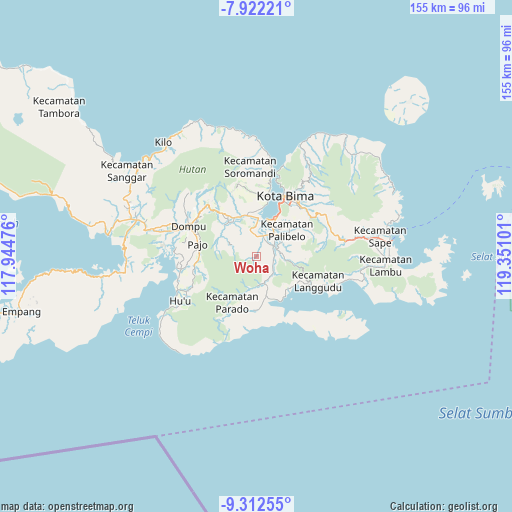
Woha GPS coordinates[2]
8° 37' 4.872" South, 118° 38' 52.368" East
| Map corner | latitude | longitude |
|---|---|---|
| Upper-left | -7.92221°, | 117.94476° |
| Center: | -8.61802°, | 118.64788° |
| Lower-right: | -9.31255°, | 119.35101° |
| Map W x H: | 154.6×154.6 km | = 96.1×96.1mi |
| max Lat: | 5.88969° ⇑87.3% North |
| Woha: | -8.61802° |
| min Lat: | ⇓12.7% South -10.934° |
| min Long | Woha | max Long |
| 95.1345° | 118.64788° | 140.9419° |
| W 79.9%⇐ | ⇒20.1% E |
Elevation
Elevation of Woha is 51 m = 167 ft, and this is 178.7 m = 586 ft below average elevation for this country.
| Max E: |
3185 m = 10449 ft | 62.1% |
| Avg. | 229.7 m = 754 ft | |
| Woha | 51 m = 167 ft | |
Min E: |
-1 m = -3 ft | 37.9% |
See also: Indonesia elevation on elevation.city.
Geographical zone
Woha is located in South Torrid zone (between Equator and Tropic of Capricorn). Distance of Equator is 958.2 km =595.4 mi to North.| Distance of | km | miles | from Woha |
|---|---|---|---|
| Equator | 958.2 | 595.4 | to North |
| Tropic Capricorn | 1647.7 | 1023.8 | to South |
| Antarctic Circle | 6442.9 | 4003.4 | to South |
| South Pole | 9048.8 | 5622.7 | to South |


Nearby cities:
15 places around Woha: (largest is in red/bold)
• Campa
8.2 km =5.1 mi,  295°
295°
• Godo
6.6 km =4.1 mi,  17°
17°
• Leu
12.7 km =7.9 mi,  348°
348°
• Lido
9.6 km =6 mi,  97°
97°
• Melati
12.6 km =7.8 mi, 347°
• Ncera
10.8 km =6.7 mi, 100°
• Ompuboi
6.9 km =4.3 mi, 99°
• Rato
12.8 km =8 mi, 346°
• Sila
13.2 km =8.2 mi, 346°
• Simpasai
8.4 km =5.2 mi,  166°
166°
• Tambe
12.9 km =8 mi,  338°
338°
• Tangga
6.6 km =4.1 mi,  129°
129°
• Tolomango
13.1 km =8.1 mi, 343°
• Waworada
7.2 km =4.5 mi,  142°
142°
• Woro
12.5 km =7.8 mi,  293°
293°
Sources, notices
• [Note1] Compared only with cities in Indonesia existing in our database
• [Src1] Map data: © OpenStreetMap contributors (CC-BY-SA)
• [Src2] Other city data from geonames.org with taken over terms of usage.
• [Src3] Geographical zone / Annual Mean Temperature by Robert A. Rohde @ Wikipedia
