Sungai Raya geodata
Sungai Raya (West Kalimantan) is a seat of a second-order administrative division; located in Indonesia in Asia/Pontianak (GMT+7) time zone. In our database, there are 407 cities with bigger population. Compared to other cities in Indonesia, 95.1% of cities are located further ↓South; 66% of cities are located further →East and 99.7% of cities have higher elevation than Sungai Raya. Note1


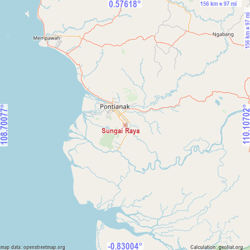
Sungai Raya GPS coordinates[2]
0° 7' 36.984" South, 109° 24' 14.004" East
| Map corner | latitude | longitude |
|---|---|---|
| Upper-left | 0.57618°, | 108.70077° |
| Center: | -0.12694°, | 109.40389° |
| Lower-right: | -0.83004°, | 110.10702° |
| Map W x H: | 156.4×156.4 km | = 97.2×97.2mi |
| max Lat: | 5.88969° ⇑4.9% North |
| Sungai Raya: | -0.12694° |
| min Lat: | ⇓95.1% South -10.934° |
| min Long | Sungai Raya | max Long |
| 95.1345° | 109.40389° | 140.9419° |
| W 34%⇐ | ⇒66% E |
Elevation
Elevation of Sungai Raya is 2 m = 7 ft, and this is 227.7 m = 747 ft below average elevation for this country.
| Max E: |
3185 m = 10449 ft | 99.7% |
| Avg. | 229.7 m = 754 ft | |
| Sungai Raya | 2 m = 7 ft | |
Min E: |
-1 m = -3 ft | 0.3% |
See also: Indonesia elevation on elevation.city.
Geographical zone
Sungai Raya is located in South Torrid zone (between Equator and Tropic of Capricorn). Distance of Equator is 14.1 km =8.8 mi to North.| Distance of | km | miles | from Sungai Raya |
|---|---|---|---|
| Equator | 14.1 | 8.8 | to North |
| Tropic Capricorn | 2591.8 | 1610.5 | to South |
| Antarctic Circle | 7387.1 | 4590.1 | to South |
| South Pole | 9992.9 | 6209.3 | to South |


Nearby cities:
15 places around Sungai Raya: (largest is in red/bold)
• Batuampar
69.3 km =43.1 mi,  168°
168°
• Karangan
76.4 km =47.5 mi,  357°
357°
• Kubu
40.3 km =25 mi,  187°
187°
• Mandor
50.5 km =31.4 mi,  351°
351°
• Mempawah
73.4 km =45.6 mi,  318°
318°
• Menjalin
66.7 km =41.4 mi, 353°
• Padangtikar
64.7 km =40.2 mi, 193°
• Pontianak
13.7 km =8.5 mi, 320°
• Pontianak Barat
15.3 km =9.5 mi, 321°
• Sungai Pinyuh
58.2 km =36.2 mi, 321°
• Sungaikakap
23.4 km =14.5 mi,  290°
290°
• Tayan
78.3 km =48.7 mi,  82°
82°
• Telukpakedai
35 km =21.7 mi,  244°
244°
• Terentang
37.3 km =23.2 mi,  139°
139°
• Toho
63.9 km =39.7 mi,  341°
341°
Sources, notices
• [Note1] Compared only with cities in Indonesia existing in our database
• [Src1] Map data: © OpenStreetMap contributors (CC-BY-SA)
• [Src2] Other city data from geonames.org with taken over terms of usage.
• [Src3] Geographical zone / Annual Mean Temperature by Robert A. Rohde @ Wikipedia
