Mempawah geodata
Mempawah (West Kalimantan) is a seat of a second-order administrative division; located in Indonesia in Asia/Pontianak (GMT+7) time zone. In our database, there are 407 cities with bigger population. Compared to other cities in Indonesia, 95.4% of cities are located further ↓South; 67% of cities are located further →East and 100% of cities have higher elevation than Mempawah. Note1


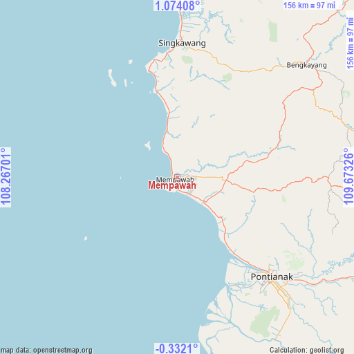
Mempawah GPS coordinates[2]
0° 22' 15.672" North, 108° 58' 12.468" East
| Map corner | latitude | longitude |
|---|---|---|
| Upper-left | 1.07408°, | 108.26701° |
| Center: | 0.37102°, | 108.97013° |
| Lower-right: | -0.3321°, | 109.67326° |
| Map W x H: | 156.4×156.4 km | = 97.2×97.2mi |
| max Lat: | 5.88969° ⇑4.6% North |
| Mempawah: | 0.37102° |
| min Lat: | ⇓95.4% South -10.934° |
| min Long | Mempawah | max Long |
| 95.1345° | 108.97013° | 140.9419° |
| W 33%⇐ | ⇒67% E |
Elevation
Elevation of Mempawah is 0 m = 0 ft, and this is 229.7 m = 754 ft below average elevation for this country.
| Max E: |
3185 m = 10449 ft | 100% |
| Avg. | 229.7 m = 754 ft | |
| Mempawah | 0 m = 0 ft | |
Min E: |
-1 m = -3 ft | 0% |
See also: Indonesia elevation on elevation.city.
Geographical zone
Mempawah is located in North Torrid zone (between Equator and Tropic of Cancer). Distance of Equator is 41.3 km =25.7 mi to South.| Distance of | km | miles | from Mempawah |
|---|---|---|---|
| North Pole | 9965.8 | 6192.5 | to North |
| Arctic Circle | 7359.9 | 4573.2 | to North |
| Tropic Cancer | 2564.7 | 1593.6 | to North |
| Equator | 41.3 | 25.7 | to South |


Nearby cities:
15 places around Mempawah: (largest is in red/bold)
• Bengkayang
72.9 km =45.3 mi,  45°
45°
• Karangan
49.7 km =30.9 mi,  65°
65°
• Mandor
41.3 km =25.7 mi,  97°
97°
• Menjalin
42.4 km =26.3 mi,  75°
75°
• Pontianak
59.7 km =37.1 mi,  138°
138°
• Pontianak Barat
58.2 km =36.2 mi, 138°
• Samalantan
53.2 km =33.1 mi,  28°
28°
• Singkawang
59.9 km =37.2 mi,  1°
1°
• Sungai Pinyuh
15.5 km =9.6 mi,  128°
128°
• Sungai Raya
37.4 km =23.2 mi,  347°
347°
• Sungai Raya
73.4 km =45.6 mi, 138°
• Sungaiduri
22.2 km =13.8 mi, 348°
• Sungaikakap
53.9 km =33.5 mi,  150°
150°
• Telukpakedai
72.7 km =45.2 mi,  166°
166°
• Toho
28.3 km =17.6 mi, 79°
Sources, notices
• [Note1] Compared only with cities in Indonesia existing in our database
• [Src1] Map data: © OpenStreetMap contributors (CC-BY-SA)
• [Src2] Other city data from geonames.org with taken over terms of usage.
• [Src3] Geographical zone / Annual Mean Temperature by Robert A. Rohde @ Wikipedia
