Langsa geodata
Langsa (Aceh) is a populated place; located in Indonesia in Asia/Jakarta (GMT+7) time zone. With population of 54,465 people, there are 220 cities with bigger population in this country. Compared to other cities in Indonesia, 99.1% of cities are located further ↓South; 98.4% of cities are located further →East and 90.6% of cities have higher elevation than Langsa. Note1


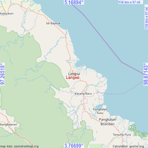
Langsa GPS coordinates[2]
4° 28' 5.88" North, 97° 58' 5.88" East
| Map corner | latitude | longitude |
|---|---|---|
| Upper-left | 5.16894°, | 97.26518° |
| Center: | 4.4683°, | 97.9683° |
| Lower-right: | 3.76699°, | 98.67143° |
| Map W x H: | 155.9×155.9 km | = 96.9×96.9mi |
| max Lat: | 5.88969° ⇑0.9% North |
| Langsa: | 4.4683° |
| min Lat: | ⇓99.1% South -10.934° |
| min Long | Langsa | max Long |
| 95.1345° | 97.9683° | 140.9419° |
| W 1.6%⇐ | ⇒98.4% E |
Elevation
Elevation of Langsa is 10 m = 33 ft, and this is 219.7 m = 721 ft below average elevation for this country.
| Max E: |
3185 m = 10449 ft | 90.6% |
| Avg. | 229.7 m = 754 ft | |
| Langsa | 10 m = 33 ft | |
Min E: |
-1 m = -3 ft | 9.4% |
See also: Langsa elevation on elevation.city.
Geographical zone
Langsa is located in North Torrid zone (between Equator and Tropic of Cancer). Distance of Equator is 496.8 km =308.7 mi to South.| Distance of | km | miles | from Langsa |
|---|---|---|---|
| North Pole | 9510.2 | 5909.4 | to North |
| Arctic Circle | 6904.3 | 4290.1 | to North |
| Tropic Cancer | 2109.1 | 1310.5 | to North |
| Equator | 496.8 | 308.7 | to South |


Nearby cities:
15 places around Langsa: (largest is in red/bold)
• Bayeuen
15.1 km =9.4 mi,  334°
334°
• Beusa Seberang
46.7 km =29 mi,  344°
344°
• Buket Teukuh
51.1 km =31.8 mi,  317°
317°
• Idi Rayeuk
55 km =34.2 mi, 339°
• Karangbaru
19.2 km =11.9 mi,  160°
160°
• Penaron
36.9 km =22.9 mi,  301°
301°
• Peureulak
38.9 km =24.2 mi,  347°
347°
• Pulau Tiga
39.3 km =24.4 mi,  194°
194°
• Rantau Panjang
37.1 km =23.1 mi, 320°
• Serawai
27.3 km =17 mi,  117°
117°
• Sungai Iyu
19.5 km =12.1 mi,  111°
111°
• Sungai Raya
33.2 km =20.6 mi, 349°
• Sungi Liput
29.4 km =18.3 mi,  170°
170°
• Tenggulun
53.2 km =33.1 mi,  175°
175°
• Tualangcut
13.7 km =8.5 mi, 122°
Sources, notices
• [Note1] Compared only with cities in Indonesia existing in our database
• [Src1] Map data: © OpenStreetMap contributors (CC-BY-SA)
• [Src2] Other city data from geonames.org with taken over terms of usage.
• [Src3] Geographical zone / Annual Mean Temperature by Robert A. Rohde @ Wikipedia
