Serawai geodata
Serawai (Aceh) is a seat of a third-order administrative division; located in Indonesia in Asia/Jakarta (GMT+7) time zone. In our database, there are 407 cities with bigger population. Compared to other cities in Indonesia, 99.1% of cities are located further ↓South; 98.4% of cities are located further →East and 97.2% of cities have higher elevation than Serawai. Note1


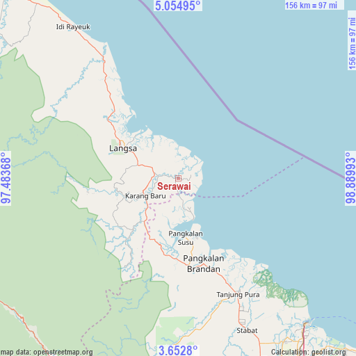
Serawai GPS coordinates[2]
4° 21' 15.12" North, 98° 11' 12.48" East
| Map corner | latitude | longitude |
|---|---|---|
| Upper-left | 5.05495°, | 97.48368° |
| Center: | 4.3542°, | 98.1868° |
| Lower-right: | 3.6528°, | 98.88993° |
| Map W x H: | 155.9×155.9 km | = 96.9×96.9mi |
| max Lat: | 5.88969° ⇑0.9% North |
| Serawai: | 4.3542° |
| min Lat: | ⇓99.1% South -10.934° |
| min Long | Serawai | max Long |
| 95.1345° | 98.1868° | 140.9419° |
| W 1.6%⇐ | ⇒98.4% E |
Elevation
Elevation of Serawai is 6 m = 20 ft, and this is 223.7 m = 734 ft below average elevation for this country.
| Max E: |
3185 m = 10449 ft | 97.2% |
| Avg. | 229.7 m = 754 ft | |
| Serawai | 6 m = 20 ft | |
Min E: |
-1 m = -3 ft | 2.8% |
See also: Indonesia elevation on elevation.city.
Geographical zone
Serawai is located in North Torrid zone (between Equator and Tropic of Cancer). Distance of Equator is 484.1 km =300.8 mi to South.| Distance of | km | miles | from Serawai |
|---|---|---|---|
| North Pole | 9522.9 | 5917.3 | to North |
| Arctic Circle | 6917 | 4298 | to North |
| Tropic Cancer | 2121.8 | 1318.4 | to North |
| Equator | 484.1 | 300.8 | to South |


Nearby cities:
15 places around Serawai: (largest is in red/bold)
• Bayeuen
40.5 km =25.2 mi,  310°
310°
• Beusa Seberang
68.4 km =42.5 mi,  327°
327°
• Karangbaru
18.5 km =11.5 mi,  253°
253°
• Langsa
27.3 km =17 mi,  297°
297°
• Pangkalan Brandan
38.1 km =23.7 mi,  164°
164°
• Penaron
64.2 km =39.9 mi, 299°
• Peureulak
60.4 km =37.5 mi, 327°
• Pulau Tiga
42.6 km =26.5 mi,  233°
233°
• Rantau Panjang
63.1 km =39.2 mi, 311°
• Sungai Iyu
8.3 km =5.2 mi, 313°
• Sungai Raya
54.6 km =33.9 mi, 326°
• Sungi Liput
25.3 km =15.7 mi, 229°
• Tanjungtiram
38.4 km =23.9 mi,  148°
148°
• Tenggulun
45 km =28 mi,  206°
206°
• Tualangcut
13.8 km =8.6 mi,  292°
292°
Sources, notices
• [Note1] Compared only with cities in Indonesia existing in our database
• [Src1] Map data: © OpenStreetMap contributors (CC-BY-SA)
• [Src2] Other city data from geonames.org with taken over terms of usage.
• [Src3] Geographical zone / Annual Mean Temperature by Robert A. Rohde @ Wikipedia
