Kenyaran geodata
Kenyaran (Aceh) is a seat of a third-order administrative division; located in Indonesia in Asia/Jakarta (GMT+7) time zone. In our database, there are 407 cities with bigger population. Compared to other cities in Indonesia, 98.9% of cities are located further ↓South; 99% of cities are located further →East and 98.7% of cities have lower elevation than Kenyaran. Note1


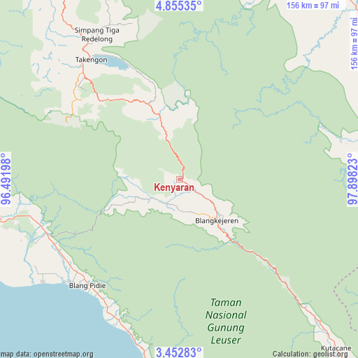
Kenyaran GPS coordinates[2]
4° 9' 15.84" North, 97° 11' 42.36" East
| Map corner | latitude | longitude |
|---|---|---|
| Upper-left | 4.85535°, | 96.49198° |
| Center: | 4.1544°, | 97.1951° |
| Lower-right: | 3.45283°, | 97.89823° |
| Map W x H: | 155.9×155.9 km | = 96.9×96.9mi |
| max Lat: | 5.88969° ⇑1.1% North |
| Kenyaran: | 4.1544° |
| min Lat: | ⇓98.9% South -10.934° |
| min Long | Kenyaran | max Long |
| 95.1345° | 97.1951° | 140.9419° |
| W 1%⇐ | ⇒99% E |
Elevation
Elevation of Kenyaran is 1170 m = 3839 ft, and this is 940.3 m = 3085 ft above average elevation for this country.
| Max E: |
3185 m = 10449 ft | 1.3% |
| Kenyaran | 1170 m 3839 ft | |
| Avg. | 229.7 m = 754 ft | |
Min E: |
-1 m = -3 ft | 98.7% |
See also: Indonesia elevation on elevation.city.
Geographical zone
Kenyaran is located in North Torrid zone (between Equator and Tropic of Cancer). Distance of Equator is 461.9 km =287 mi to South.| Distance of | km | miles | from Kenyaran |
|---|---|---|---|
| North Pole | 9545.1 | 5931 | to North |
| Arctic Circle | 6939.2 | 4311.8 | to North |
| Tropic Cancer | 2144 | 1332.2 | to North |
| Equator | 461.9 | 287 | to South |


Nearby cities:
15 places around Kenyaran: (largest is in red/bold)
• Babah Rot
61.5 km =38.2 mi,  245°
245°
• Blangkejeren
23.6 km =14.7 mi,  137°
137°
• Blangpidie
60.9 km =37.8 mi,  220°
220°
• Isak
48.6 km =30.2 mi,  314°
314°
• Jagongjeget
51.6 km =32.1 mi,  300°
300°
• Kotabahagia
60.5 km =37.6 mi,  231°
231°
• Kuala Bintang
53.4 km =33.2 mi,  331°
331°
• Kutapanjang
13.8 km =8.6 mi,  160°
160°
• Pining
44 km =27.3 mi,  96°
96°
• Rikitgaib
15.3 km =9.5 mi,  265°
265°
• Sangir
47.4 km =29.5 mi,  128°
128°
• Suek
59.4 km =36.9 mi, 224°
• Susoh
63.3 km =39.3 mi, 220°
• Tangantangancut
62 km =38.5 mi,  213°
213°
• Terangun
16.6 km =10.3 mi,  238°
238°
Sources, notices
• [Note1] Compared only with cities in Indonesia existing in our database
• [Src1] Map data: © OpenStreetMap contributors (CC-BY-SA)
• [Src2] Other city data from geonames.org with taken over terms of usage.
• [Src3] Geographical zone / Annual Mean Temperature by Robert A. Rohde @ Wikipedia
