Babah Rot geodata
Babah Rot (Aceh) is a seat of a third-order administrative division; located in Indonesia in Asia/Jakarta (GMT+7) time zone. In our database, there are 407 cities with bigger population. Compared to other cities in Indonesia, 98.7% of cities are located further ↓South; 99.4% of cities are located further →East and 55.3% of cities have higher elevation than Babah Rot. Note1


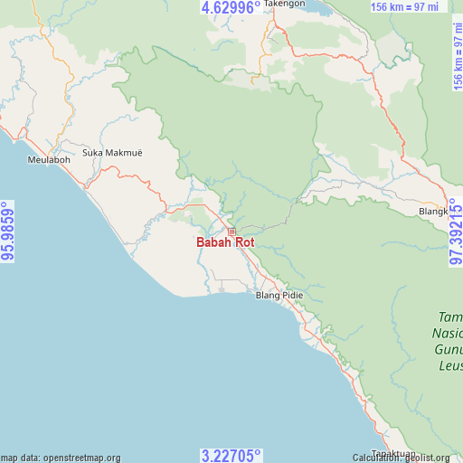
Babah Rot GPS coordinates[2]
3° 55' 43.68" North, 96° 41' 20.472" East
| Map corner | latitude | longitude |
|---|---|---|
| Upper-left | 4.62996°, | 95.9859° |
| Center: | 3.9288°, | 96.68902° |
| Lower-right: | 3.22705°, | 97.39215° |
| Map W x H: | 156×156 km | = 96.9×96.9mi |
| max Lat: | 5.88969° ⇑1.3% North |
| Babah Rot: | 3.9288° |
| min Lat: | ⇓98.7% South -10.934° |
| min Long | Babah Rot | max Long |
| 95.1345° | 96.68902° | 140.9419° |
| W 0.6%⇐ | ⇒99.4% E |
Elevation
Elevation of Babah Rot is 83 m = 272 ft, and this is 146.7 m = 481 ft below average elevation for this country.
| Max E: |
3185 m = 10449 ft | 55.3% |
| Avg. | 229.7 m = 754 ft | |
| Babah Rot | 83 m = 272 ft | |
Min E: |
-1 m = -3 ft | 44.7% |
See also: Indonesia elevation on elevation.city.
Geographical zone
Babah Rot is located in North Torrid zone (between Equator and Tropic of Cancer). Distance of Equator is 436.8 km =271.4 mi to South.| Distance of | km | miles | from Babah Rot |
|---|---|---|---|
| North Pole | 9570.2 | 5946.6 | to North |
| Arctic Circle | 6964.3 | 4327.4 | to North |
| Tropic Cancer | 2169.1 | 1347.8 | to North |
| Equator | 436.8 | 271.4 | to South |


Nearby cities:
15 places around Babah Rot: (largest is in red/bold)
• Alue Bilie
16.6 km =10.3 mi,  300°
300°
• Beutong Ateuh
45.4 km =28.2 mi,  322°
322°
• Blang Ara
52.8 km =32.8 mi, 318°
• Blangpidie
26.6 km =16.5 mi,  142°
142°
• Jagongjeget
52.3 km =32.5 mi,  12°
12°
• Kota Trieng
47.6 km =29.6 mi, 140°
• Kotabahagia
14.9 km =9.3 mi,  145°
145°
• Kuala Tuha
51.4 km =31.9 mi,  286°
286°
• Peuleumat
58.6 km =36.4 mi, 139°
• Rikitgaib
47.4 km =29.5 mi,  59°
59°
• Suek
22.3 km =13.9 mi, 140°
• Suka Makmue
11.4 km =7.1 mi, 316°
• Susoh
27.1 km =16.8 mi, 147°
• Tangantangancut
34.8 km =21.6 mi, 140°
• Terangun
45 km =28 mi,  68°
68°
Sources, notices
• [Note1] Compared only with cities in Indonesia existing in our database
• [Src1] Map data: © OpenStreetMap contributors (CC-BY-SA)
• [Src2] Other city data from geonames.org with taken over terms of usage.
• [Src3] Geographical zone / Annual Mean Temperature by Robert A. Rohde @ Wikipedia
