Krajan Rowokangkung geodata
Krajan Rowokangkung (East Java) is a seat of a fourth-order administrative division; located in Indonesia in Asia/Jakarta (GMT+7) time zone. In our database, there are 407 cities with bigger population. Compared to other cities in Indonesia, 71.2% of cities are located further ↑North; 61.1% of cities are located further ←West and 79.9% of cities have higher elevation than Krajan Rowokangkung. Note1


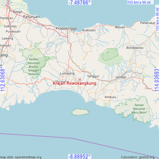
Krajan Rowokangkung GPS coordinates[2]
8° 11' 39.12" South, 113° 20' 1.68" East
| Map corner | latitude | longitude |
|---|---|---|
| Upper-left | -7.49766°, | 112.63068° |
| Center: | -8.1942°, | 113.3338° |
| Lower-right: | -8.88952°, | 114.03693° |
| Map W x H: | 154.8×154.8 km | = 96.2×96.2mi |
| max Lat: | 5.88969° ⇑71.2% North |
| Krajan Rowokangkung: | -8.1942° |
| min Lat: | ⇓28.8% South -10.934° |
| min Long | Krajan Rowokang | max Long |
| 95.1345° | 113.3338° | 140.9419° |
| W 61.1%⇐ | ⇒38.9% E |
Elevation
Elevation of Krajan Rowokangkung is 19 m = 62 ft, and this is 210.7 m = 691 ft below average elevation for this country.
| Max E: |
3185 m = 10449 ft | 79.9% |
| Avg. | 229.7 m = 754 ft | |
| Krajan Rowokangkung | 19 m = 62 ft | |
Min E: |
-1 m = -3 ft | 20.1% |
See also: Indonesia elevation on elevation.city.
Geographical zone
Krajan Rowokangkung is located in South Torrid zone (between Equator and Tropic of Capricorn). Distance of Equator is 911.1 km =566.1 mi to North.| Distance of | km | miles | from Krajan Rowokangkung |
|---|---|---|---|
| Equator | 911.1 | 566.1 | to North |
| Tropic Capricorn | 1694.8 | 1053.1 | to South |
| Antarctic Circle | 6490.1 | 4032.8 | to South |
| South Pole | 9096 | 5652 | to South |


Nearby cities:
15 places around Krajan Rowokangkung: (largest is in red/bold)
• Jombang
5.5 km =3.4 mi,  218°
218°
• Kebonsari
6.2 km =3.9 mi,  200°
200°
• Krajan Dua Padomasan
4.4 km =2.7 mi, 201°
• Krajan Kidul Rojopolo
6.6 km =4.1 mi,  352°
352°
• Krajan Tekung
5.9 km =3.7 mi,  289°
289°
• Ngampelrejo
5.5 km =3.4 mi,  120°
120°
• Nogosari
4.5 km =2.8 mi,  278°
278°
• Pondokrejo
3 km =1.9 mi,  241°
241°
• Rowokangkung
0.5 km =0.3 mi,  265°
265°
• Rowotengah
7.3 km =4.5 mi,  55°
55°
• Sebaren
5.1 km =3.2 mi,  160°
160°
• Tegalsari
5.3 km =3.3 mi, 279°
• Tekung
6.4 km =4 mi, 291°
• Wringinagung
6.5 km =4 mi,  103°
103°
• Yosowilangun
5.5 km =3.4 mi, 204°
Sources, notices
• [Note1] Compared only with cities in Indonesia existing in our database
• [Src1] Map data: © OpenStreetMap contributors (CC-BY-SA)
• [Src2] Other city data from geonames.org with taken over terms of usage.
• [Src3] Geographical zone / Annual Mean Temperature by Robert A. Rohde @ Wikipedia
