Utan geodata
Utan (West Nusa Tenggara) is a seat of a third-order administrative division; located in Indonesia in Asia/Makassar (GMT+8) time zone. In our database, there are 407 cities with bigger population. Compared to other cities in Indonesia, 80.7% of cities are located further ↑North; 78.6% of cities are located further ←West and 69.5% of cities have higher elevation than Utan. Note1


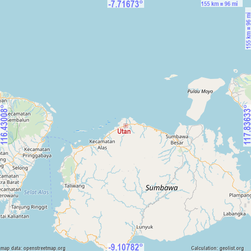
Utan GPS coordinates[2]
8° 24' 46.44" South, 117° 7' 59.52" East
| Map corner | latitude | longitude |
|---|---|---|
| Upper-left | -7.71673°, | 116.43008° |
| Center: | -8.4129°, | 117.1332° |
| Lower-right: | -9.10782°, | 117.83633° |
| Map W x H: | 154.7×154.7 km | = 96.1×96.1mi |
| max Lat: | 5.88969° ⇑80.7% North |
| Utan: | -8.4129° |
| min Lat: | ⇓19.3% South -10.934° |
| min Long | Utan | max Long |
| 95.1345° | 117.1332° | 140.9419° |
| W 78.6%⇐ | ⇒21.4% E |
Elevation
Elevation of Utan is 33 m = 108 ft, and this is 196.7 m = 645 ft below average elevation for this country.
| Max E: |
3185 m = 10449 ft | 69.5% |
| Avg. | 229.7 m = 754 ft | |
| Utan | 33 m = 108 ft | |
Min E: |
-1 m = -3 ft | 30.5% |
See also: Indonesia elevation on elevation.city.
Geographical zone
Utan is located in South Torrid zone (between Equator and Tropic of Capricorn). Distance of Equator is 935.4 km =581.2 mi to North.| Distance of | km | miles | from Utan |
|---|---|---|---|
| Equator | 935.4 | 581.2 | to North |
| Tropic Capricorn | 1670.5 | 1038 | to South |
| Antarctic Circle | 6465.7 | 4017.6 | to South |
| South Pole | 9071.6 | 5636.8 | to South |


Nearby cities:
15 places around Utan: (largest is in red/bold)
• Baru
19.7 km =12.2 mi,  231°
231°
• Dalam
19 km =11.8 mi, 233°
• Jorok Dalam
0.3 km =0.2 mi,  50°
50°
• Juranalas
19.3 km =12 mi, 230°
• Kalimango
19.4 km =12.1 mi, 231°
• Luar
19.4 km =12.1 mi, 232°
• Lukkarya
17.1 km =10.6 mi,  95°
95°
• Marenteh
19.6 km =12.2 mi,  220°
220°
• Motong Barat
0.3 km =0.2 mi, 222°
• Orong
0.4 km =0.2 mi,  268°
268°
• Rhee Beru
11.3 km =7 mi,  92°
92°
• Satowebrang
0.8 km =0.5 mi,  244°
244°
• Sebedo
3.7 km =2.3 mi,  118°
118°
• Seseng
12.3 km =7.6 mi, 119°
• Tengah Satu
0.7 km =0.4 mi,  203°
203°
Sources, notices
• [Note1] Compared only with cities in Indonesia existing in our database
• [Src1] Map data: © OpenStreetMap contributors (CC-BY-SA)
• [Src2] Other city data from geonames.org with taken over terms of usage.
• [Src3] Geographical zone / Annual Mean Temperature by Robert A. Rohde @ Wikipedia
