Seseng geodata
Seseng (West Nusa Tenggara) is a seat of a fourth-order administrative division; located in Indonesia in Asia/Makassar (GMT+8) time zone. In our database, there are 407 cities with bigger population. Compared to other cities in Indonesia, 82.2% of cities are located further ↑North; 78.8% of cities are located further ←West and 66.1% of cities have higher elevation than Seseng. Note1


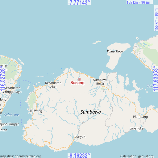
Seseng GPS coordinates[2]
8° 28' 3" South, 117° 13' 49.44" East
| Map corner | latitude | longitude |
|---|---|---|
| Upper-left | -7.77143°, | 116.52728° |
| Center: | -8.4675°, | 117.2304° |
| Lower-right: | -9.16232°, | 117.93353° |
| Map W x H: | 154.7×154.7 km | = 96.1×96.1mi |
| max Lat: | 5.88969° ⇑82.2% North |
| Seseng: | -8.4675° |
| min Lat: | ⇓17.8% South -10.934° |
| min Long | Seseng | max Long |
| 95.1345° | 117.2304° | 140.9419° |
| W 78.8%⇐ | ⇒21.2% E |
Elevation
Elevation of Seseng is 40 m = 131 ft, and this is 189.7 m = 622 ft below average elevation for this country.
| Max E: |
3185 m = 10449 ft | 66.1% |
| Avg. | 229.7 m = 754 ft | |
| Seseng | 40 m = 131 ft | |
Min E: |
-1 m = -3 ft | 33.9% |
See also: Indonesia elevation on elevation.city.
Geographical zone
Seseng is located in South Torrid zone (between Equator and Tropic of Capricorn). Distance of Equator is 941.5 km =585 mi to North.| Distance of | km | miles | from Seseng |
|---|---|---|---|
| Equator | 941.5 | 585 | to North |
| Tropic Capricorn | 1664.4 | 1034.2 | to South |
| Antarctic Circle | 6459.7 | 4013.9 | to South |
| South Pole | 9065.6 | 5633.1 | to South |


Nearby cities:
15 places around Seseng: (largest is in red/bold)
• Batudulang
14.4 km =8.9 mi,  157°
157°
• Jorok Dalam
12.2 km =7.6 mi,  300°
300°
• Karangdima
17.8 km =11.1 mi,  92°
92°
• Kelungkung
15 km =9.3 mi,  128°
128°
• Labuhanbadas
15.1 km =9.4 mi, 88°
• Lukkarya
7.7 km =4.8 mi,  55°
55°
• Motong Barat
12.4 km =7.7 mi, 298°
• Orong
12.6 km =7.8 mi, 298°
• Rhee Beru
5.5 km =3.4 mi,  6°
6°
• Satowebrang
12.8 km =8 mi, 296°
• Sebedo
8.6 km =5.3 mi, 300°
• Semongkat
15.2 km =9.4 mi,  139°
139°
• Tengah Satu
12.2 km =7.6 mi, 296°
• Tepal
18.5 km =11.5 mi,  197°
197°
• Utan
12.3 km =7.6 mi, 299°
Sources, notices
• [Note1] Compared only with cities in Indonesia existing in our database
• [Src1] Map data: © OpenStreetMap contributors (CC-BY-SA)
• [Src2] Other city data from geonames.org with taken over terms of usage.
• [Src3] Geographical zone / Annual Mean Temperature by Robert A. Rohde @ Wikipedia
