Ubud geodata
Ubud (Bali) is a populated place; located in Indonesia in Asia/Makassar (GMT+8) time zone. With population of 28,373 people, there are 326 cities with bigger population in this country. Compared to other cities in Indonesia, 83.8% of cities are located further ↑North; 73.2% of cities are located further ←West and 64.1% of cities have lower elevation than Ubud. Note1


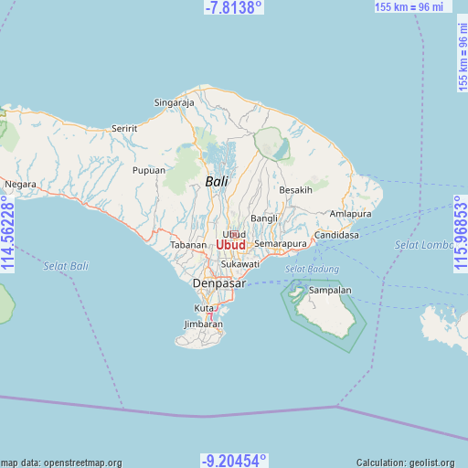
Ubud GPS coordinates[2]
8° 30' 35.28" South, 115° 15' 55.44" East
| Map corner | latitude | longitude |
|---|---|---|
| Upper-left | -7.8138°, | 114.56228° |
| Center: | -8.5098°, | 115.2654° |
| Lower-right: | -9.20454°, | 115.96853° |
| Map W x H: | 154.6×154.6 km | = 96.1×96.1mi |
| max Lat: | 5.88969° ⇑83.8% North |
| Ubud: | -8.5098° |
| min Lat: | ⇓16.2% South -10.934° |
| min Long | Ubud | max Long |
| 95.1345° | 115.2654° | 140.9419° |
| W 73.2%⇐ | ⇒26.8% E |
Elevation
Elevation of Ubud is 210 m = 689 ft, and this is 19.7 m = 65 ft below average elevation for this country.
| Max E: |
3185 m = 10449 ft | 35.9% |
| Avg. | 229.7 m = 754 ft | |
| Ubud | 210 m = 689 ft | |
Min E: |
-1 m = -3 ft | 64.1% |
See also: Indonesia elevation on elevation.city.
Geographical zone
Ubud is located in South Torrid zone (between Equator and Tropic of Capricorn). Distance of Equator is 946.2 km =587.9 mi to North.| Distance of | km | miles | from Ubud |
|---|---|---|---|
| Equator | 946.2 | 587.9 | to North |
| Tropic Capricorn | 1659.7 | 1031.3 | to South |
| Antarctic Circle | 6455 | 4010.9 | to South |
| South Pole | 9060.9 | 5630.2 | to South |


Nearby cities:
15 places around Ubud: (largest is in red/bold)
• Banjar Kembangsari
6 km =3.7 mi,  270°
270°
• Banjar Keraman
6.2 km =3.9 mi,  251°
251°
• Banjar Mambalkajanan
6.5 km =4 mi,  225°
225°
• Banjar Mulung
6.1 km =3.8 mi,  55°
55°
• Banjar Pande
2.8 km =1.7 mi,  263°
263°
• Banjar Pesalakan
5.2 km =3.2 mi,  52°
52°
• Banjar Petuludesa
2.7 km =1.7 mi,  20°
20°
• Banjar Sandinggianyar
6.4 km =4 mi,  35°
35°
• Banjar Tebongkang
3.2 km =2 mi, 228°
• Banjar Teguan
3.9 km =2.4 mi,  276°
276°
• Banjar Triwangsakeliki
6.4 km =4 mi,  356°
356°
• Banjar Ubud
4.8 km =3 mi, 39°
• Banjar Ulapan Satu
5.6 km =3.5 mi, 270°
• Bunutan
5.3 km =3.3 mi,  339°
339°
• Pegongan
5.1 km =3.2 mi,  302°
302°
Sources, notices
• [Note1] Compared only with cities in Indonesia existing in our database
• [Src1] Map data: © OpenStreetMap contributors (CC-BY-SA)
• [Src2] Other city data from geonames.org with taken over terms of usage.
• [Src3] Geographical zone / Annual Mean Temperature by Robert A. Rohde @ Wikipedia
