Bunutan geodata
Bunutan (Bali) is a seat of a fourth-order administrative division; located in Indonesia in Asia/Makassar (GMT+8) time zone. In our database, there are 407 cities with bigger population. Compared to other cities in Indonesia, 82.2% of cities are located further ↑North; 73% of cities are located further ←West and 72% of cities have lower elevation than Bunutan. Note1


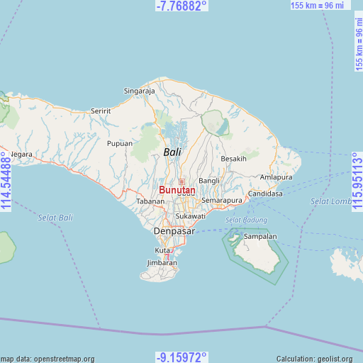
Bunutan GPS coordinates[2]
8° 27' 53.64" South, 115° 14' 52.8" East
| Map corner | latitude | longitude |
|---|---|---|
| Upper-left | -7.76882°, | 114.54488° |
| Center: | -8.4649°, | 115.248° |
| Lower-right: | -9.15972°, | 115.95113° |
| Map W x H: | 154.7×154.7 km | = 96.1×96.1mi |
| max Lat: | 5.88969° ⇑82.2% North |
| Bunutan: | -8.4649° |
| min Lat: | ⇓17.8% South -10.934° |
| min Long | Bunutan | max Long |
| 95.1345° | 115.248° | 140.9419° |
| W 73%⇐ | ⇒27% E |
Elevation
Elevation of Bunutan is 321 m = 1053 ft, and this is 91.3 m = 300 ft above average elevation for this country.
| Max E: |
3185 m = 10449 ft | 28% |
| Bunutan | 321 m 1053 ft | |
| Avg. | 229.7 m = 754 ft | |
Min E: |
-1 m = -3 ft | 72% |
See also: Indonesia elevation on elevation.city.
Geographical zone
Bunutan is located in South Torrid zone (between Equator and Tropic of Capricorn). Distance of Equator is 941.2 km =584.8 mi to North.| Distance of | km | miles | from Bunutan |
|---|---|---|---|
| Equator | 941.2 | 584.8 | to North |
| Tropic Capricorn | 1664.7 | 1034.4 | to South |
| Antarctic Circle | 6460 | 4014.1 | to South |
| South Pole | 9065.9 | 5633.3 | to South |


Nearby cities:
15 places around Bunutan: (largest is in red/bold)
• Banjar Pande
5.4 km =3.4 mi,  189°
189°
• Banjar Petuludesa
3.8 km =2.4 mi,  130°
130°
• Banjar Sandinggianyar
5.6 km =3.5 mi,  87°
87°
• Banjar Teguan
5 km =3.1 mi,  203°
203°
• Banjar Tengah
4.8 km =3 mi,  71°
71°
• Banjar Triwangsakeliki
2.1 km =1.3 mi,  47°
47°
• Banjar Triwangsakelusa
2.9 km =1.8 mi,  22°
22°
• Banjar Ubud
5.1 km =3.2 mi,  104°
104°
• Bayad
2.1 km =1.3 mi,  340°
340°
• Brahmana
4.8 km =3 mi,  239°
239°
• Melinggih
3.8 km =2.4 mi,  354°
354°
• Pegongan
3.3 km =2.1 mi,  225°
225°
• Pemijian
3.6 km =2.2 mi,  297°
297°
• Tegalalang
4.7 km =2.9 mi, 47°
• Ubud
5.3 km =3.3 mi,  159°
159°
Sources, notices
• [Note1] Compared only with cities in Indonesia existing in our database
• [Src1] Map data: © OpenStreetMap contributors (CC-BY-SA)
• [Src2] Other city data from geonames.org with taken over terms of usage.
• [Src3] Geographical zone / Annual Mean Temperature by Robert A. Rohde @ Wikipedia
