Tungoo geodata
Tungoo (North Sulawesi) is a seat of a third-order administrative division; located in Indonesia in Asia/Makassar (GMT+8) time zone. In our database, there are 407 cities with bigger population. Compared to other cities in Indonesia, 95.8% of cities are located further ↓South; 95.1% of cities are located further ←West and 72.6% of cities have lower elevation than Tungoo. Note1


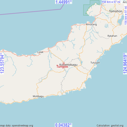
Tungoo GPS coordinates[2]
0° 44' 48.912" North, 124° 15' 39.816" East
| Map corner | latitude | longitude |
|---|---|---|
| Upper-left | 1.44991°, | 123.55794° |
| Center: | 0.74692°, | 124.26106° |
| Lower-right: | 0.04382°, | 124.96419° |
| Map W x H: | 156.3×156.3 km | = 97.1×97.1mi |
| max Lat: | 5.88969° ⇑4.2% North |
| Tungoo: | 0.74692° |
| min Lat: | ⇓95.8% South -10.934° |
| min Long | Tungoo | max Long |
| 95.1345° | 124.26106° | 140.9419° |
| W 95.1%⇐ | ⇒4.9% E |
Elevation
Elevation of Tungoo is 329 m = 1079 ft, and this is 99.3 m = 326 ft above average elevation for this country.
| Max E: |
3185 m = 10449 ft | 27.4% |
| Tungoo | 329 m 1079 ft | |
| Avg. | 229.7 m = 754 ft | |
Min E: |
-1 m = -3 ft | 72.6% |
See also: Indonesia elevation on elevation.city.
Geographical zone
Tungoo is located in North Torrid zone (between Equator and Tropic of Cancer). Distance of Equator is 83 km =51.6 mi to South.| Distance of | km | miles | from Tungoo |
|---|---|---|---|
| North Pole | 9924 | 6166.5 | to North |
| Arctic Circle | 7318.1 | 4547.3 | to North |
| Tropic Cancer | 2522.9 | 1567.7 | to North |
| Equator | 83 | 51.6 | to South |


Nearby cities:
15 places around Tungoo: (largest is in red/bold)
• Bilalang
5.3 km =3.3 mi,  56°
56°
• Bolaang
24.6 km =15.3 mi,  331°
331°
• Dumoga
25 km =15.5 mi,  232°
232°
• Kotabunan
44.4 km =27.6 mi,  80°
80°
• Lolak
31.4 km =19.5 mi,  297°
297°
• Lolayan
12.3 km =7.6 mi,  155°
155°
• Modayag
14.2 km =8.8 mi,  106°
106°
• Molibagu
50.7 km =31.5 mi,  217°
217°
• Passi
4.6 km =2.9 mi, 63°
• Poigar
27.8 km =17.3 mi,  4°
4°
• Poigar
30.9 km =19.2 mi,  9°
9°
• Tenga
50.2 km =31.2 mi,  23°
23°
• Tombatu
57.3 km =35.6 mi, 55°
• Tompasobaru
30.1 km =18.7 mi,  50°
50°
• Tutuyan
39.3 km =24.4 mi,  87°
87°
Sources, notices
• [Note1] Compared only with cities in Indonesia existing in our database
• [Src1] Map data: © OpenStreetMap contributors (CC-BY-SA)
• [Src2] Other city data from geonames.org with taken over terms of usage.
• [Src3] Geographical zone / Annual Mean Temperature by Robert A. Rohde @ Wikipedia
