Tanggulangin geodata
Tanggulangin (East Java) is a populated place; located in Indonesia in Asia/Jakarta (GMT+7) time zone. With population of 32,866 people, there are 302 cities with bigger population in this country. Compared to other cities in Indonesia, 55.8% of cities are located further ↑North; 56.9% of cities are located further ←West and 97.2% of cities have higher elevation than Tanggulangin. Note1


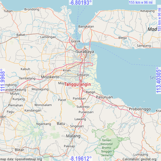
Tanggulangin GPS coordinates[2]
7° 29' 58.488" South, 112° 41' 59.712" East
| Map corner | latitude | longitude |
|---|---|---|
| Upper-left | -6.80193°, | 111.9968° |
| Center: | -7.49958°, | 112.69992° |
| Lower-right: | -8.19612°, | 113.40305° |
| Map W x H: | 155×155 km | = 96.3×96.3mi |
| max Lat: | 5.88969° ⇑55.8% North |
| Tanggulangin: | -7.49958° |
| min Lat: | ⇓44.2% South -10.934° |
| min Long | Tanggulangin | max Long |
| 95.1345° | 112.69992° | 140.9419° |
| W 56.9%⇐ | ⇒43.1% E |
Elevation
Elevation of Tanggulangin is 6 m = 20 ft, and this is 223.7 m = 734 ft below average elevation for this country.
| Max E: |
3185 m = 10449 ft | 97.2% |
| Avg. | 229.7 m = 754 ft | |
| Tanggulangin | 6 m = 20 ft | |
Min E: |
-1 m = -3 ft | 2.8% |
See also: Indonesia elevation on elevation.city.
Geographical zone
Tanggulangin is located in South Torrid zone (between Equator and Tropic of Capricorn). Distance of Equator is 833.9 km =518.2 mi to North.| Distance of | km | miles | from Tanggulangin |
|---|---|---|---|
| Equator | 833.9 | 518.2 | to North |
| Tropic Capricorn | 1772 | 1101.1 | to South |
| Antarctic Circle | 6567.3 | 4080.7 | to South |
| South Pole | 9173.2 | 5700 | to South |


Nearby cities:
15 places around Tanggulangin: (largest is in red/bold)
• Buduran
8.4 km =5.2 mi,  18°
18°
• Buncitan
14.6 km =9.1 mi,  37°
37°
• Damarsi
11.2 km =7 mi, 35°
• Dukuh Tengah
11 km =6.8 mi,  32°
32°
• Gedangan
12.4 km =7.7 mi,  13°
13°
• Kalanganyartambak
15.2 km =9.4 mi, 42°
• Kedungpeluk
6.3 km =3.9 mi,  72°
72°
• Mojosari
15.6 km =9.7 mi,  261°
261°
• Pepe
13.2 km =8.2 mi, 35°
• Sawohan
11.2 km =7 mi, 43°
• Sedati
13.8 km =8.6 mi, 32°
• Sedatiagung
14.6 km =9.1 mi, 26°
• Sedatigede
15.3 km =9.5 mi, 26°
• Sidoarjo
6.1 km =3.8 mi, 19°
• Tulangan Utara
6.2 km =3.9 mi,  297°
297°
Sources, notices
• [Note1] Compared only with cities in Indonesia existing in our database
• [Src1] Map data: © OpenStreetMap contributors (CC-BY-SA)
• [Src2] Other city data from geonames.org with taken over terms of usage.
• [Src3] Geographical zone / Annual Mean Temperature by Robert A. Rohde @ Wikipedia
