Loklaga geodata
Loklaga (South Kalimantan) is a seat of a third-order administrative division; located in Indonesia in Asia/Makassar (GMT+8) time zone. In our database, there are 407 cities with bigger population. Compared to other cities in Indonesia, 91.8% of cities are located further ↓South; 74.1% of cities are located further ←West and 64.5% of cities have higher elevation than Loklaga. Note1


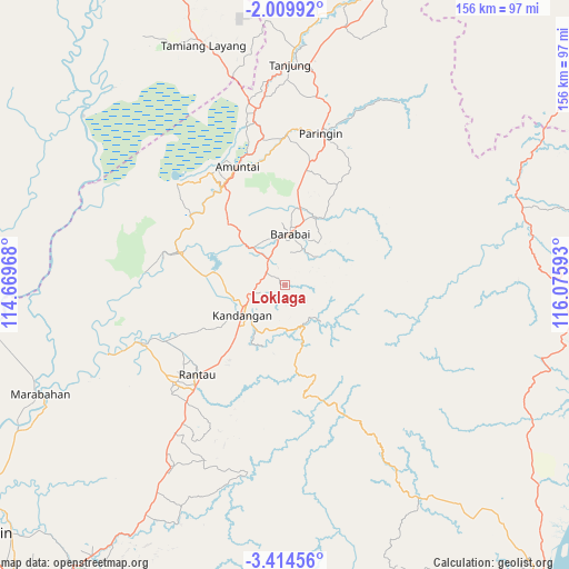
Loklaga GPS coordinates[2]
2° 42' 44.784" South, 115° 22' 22.08" East
| Map corner | latitude | longitude |
|---|---|---|
| Upper-left | -2.00992°, | 114.66968° |
| Center: | -2.71244°, | 115.3728° |
| Lower-right: | -3.41456°, | 116.07593° |
| Map W x H: | 156.2×156.2 km | = 97.1×97.1mi |
| max Lat: | 5.88969° ⇑8.2% North |
| Loklaga: | -2.71244° |
| min Lat: | ⇓91.8% South -10.934° |
| min Long | Loklaga | max Long |
| 95.1345° | 115.3728° | 140.9419° |
| W 74.1%⇐ | ⇒25.9% E |
Elevation
Elevation of Loklaga is 44 m = 144 ft, and this is 185.7 m = 609 ft below average elevation for this country.
| Max E: |
3185 m = 10449 ft | 64.5% |
| Avg. | 229.7 m = 754 ft | |
| Loklaga | 44 m = 144 ft | |
Min E: |
-1 m = -3 ft | 35.5% |
See also: Indonesia elevation on elevation.city.
Geographical zone
Loklaga is located in South Torrid zone (between Equator and Tropic of Capricorn). Distance of Equator is 301.6 km =187.4 mi to North.| Distance of | km | miles | from Loklaga |
|---|---|---|---|
| Equator | 301.6 | 187.4 | to North |
| Tropic Capricorn | 2304.3 | 1431.8 | to South |
| Antarctic Circle | 7099.6 | 4411.5 | to South |
| South Pole | 9705.5 | 6030.7 | to South |


Nearby cities:
15 places around Loklaga: (largest is in red/bold)
• Alung
22.7 km =14.1 mi,  15°
15°
• Angkimang
7.4 km =4.6 mi,  250°
250°
• Barabai
14.4 km =8.9 mi,  4°
4°
• Barikin
6.4 km =4 mi,  304°
304°
• Birayang
22 km =13.7 mi, 24°
• Haruyan
3.4 km =2.1 mi,  312°
312°
• Kandangan
13.2 km =8.2 mi,  233°
233°
• Kasarangan
12.7 km =7.9 mi,  318°
318°
• Padangbatung
16.6 km =10.3 mi,  212°
212°
• Pagat
11.9 km =7.4 mi,  34°
34°
• Pantaihambawang
8.7 km =5.4 mi,  327°
327°
• Pasingkan
18.3 km =11.4 mi,  279°
279°
• Simpur
17.4 km =10.8 mi,  222°
222°
• Sungairaya
21.2 km =13.2 mi, 220°
• Telagalangsat
23 km =14.3 mi,  112°
112°
Sources, notices
• [Note1] Compared only with cities in Indonesia existing in our database
• [Src1] Map data: © OpenStreetMap contributors (CC-BY-SA)
• [Src2] Other city data from geonames.org with taken over terms of usage.
• [Src3] Geographical zone / Annual Mean Temperature by Robert A. Rohde @ Wikipedia
