Singaparna geodata
Singaparna (West Java) is a seat of a second-order administrative division; located in Indonesia in Asia/Jakarta (GMT+7) time zone. With population of 48,882 people, there are 236 cities with bigger population in this country. Compared to other cities in Indonesia, 51.3% of cities are located further ↑North; 78.5% of cities are located further →East and 79.9% of cities have lower elevation than Singaparna. Note1


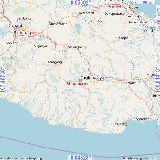
Singaparna GPS coordinates[2]
7° 21' 5.4" South, 108° 6' 39.6" East
| Map corner | latitude | longitude |
|---|---|---|
| Upper-left | -6.65362°, | 107.40788° |
| Center: | -7.3515°, | 108.111° |
| Lower-right: | -8.04828°, | 108.81413° |
| Map W x H: | 155.1×155.1 km | = 96.4×96.4mi |
| max Lat: | 5.88969° ⇑51.3% North |
| Singaparna: | -7.3515° |
| min Lat: | ⇓48.7% South -10.934° |
| min Long | Singaparna | max Long |
| 95.1345° | 108.111° | 140.9419° |
| W 21.5%⇐ | ⇒78.5% E |
Elevation
Elevation of Singaparna is 430 m = 1411 ft, and this is 200.3 m = 657 ft above average elevation for this country.
| Max E: |
3185 m = 10449 ft | 20.1% |
| Singaparna | 430 m 1411 ft | |
| Avg. | 229.7 m = 754 ft | |
Min E: |
-1 m = -3 ft | 79.9% |
See also: Singaparna elevation on elevation.city.
Geographical zone
Singaparna is located in South Torrid zone (between Equator and Tropic of Capricorn). Distance of Equator is 817.4 km =507.9 mi to North.| Distance of | km | miles | from Singaparna |
|---|---|---|---|
| Equator | 817.4 | 507.9 | to North |
| Tropic Capricorn | 1788.5 | 1111.3 | to South |
| Antarctic Circle | 6583.8 | 4091 | to South |
| South Pole | 9189.7 | 5710.2 | to South |


Nearby cities:
15 places around Singaparna: (largest is in red/bold)
• Arjasari
2 km =1.2 mi,  326°
326°
• Cidamar
3.1 km =1.9 mi,  78°
78°
• Cihampelas
2 km =1.2 mi,  137°
137°
• Cimanglid
0.8 km =0.5 mi,  18°
18°
• Cintawana
0.8 km =0.5 mi,  236°
236°
• Cisaro
1.2 km =0.7 mi,  98°
98°
• Citatah Kaler
1.6 km =1 mi,  287°
287°
• Golacir
2.9 km =1.8 mi,  33°
33°
• Panayagan
0.3 km =0.2 mi,  194°
194°
• Panugeran
1.7 km =1.1 mi,  208°
208°
• Sayuran
1.5 km =0.9 mi,  343°
343°
• Selawangi
2.5 km =1.6 mi,  319°
319°
• Sukamulya
1.3 km =0.8 mi,  132°
132°
• Tabrik
3.1 km =1.9 mi,  110°
110°
• Tambakan
2.6 km =1.6 mi,  158°
158°
Sources, notices
• [Note1] Compared only with cities in Indonesia existing in our database
• [Src1] Map data: © OpenStreetMap contributors (CC-BY-SA)
• [Src2] Other city data from geonames.org with taken over terms of usage.
• [Src3] Geographical zone / Annual Mean Temperature by Robert A. Rohde @ Wikipedia
