Cidamar geodata
Cidamar (West Java) is a seat of a fourth-order administrative division; located in Indonesia in Asia/Jakarta (GMT+7) time zone. In our database, there are 407 cities with bigger population. Compared to other cities in Indonesia, 51% of cities are located further ↑North; 78% of cities are located further →East and 78.7% of cities have lower elevation than Cidamar. Note1


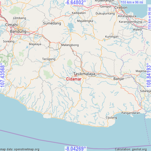
Cidamar GPS coordinates[2]
7° 20' 45.24" South, 108° 8' 19.68" East
| Map corner | latitude | longitude |
|---|---|---|
| Upper-left | -6.64802°, | 107.43568° |
| Center: | -7.3459°, | 108.1388° |
| Lower-right: | -8.04269°, | 108.84193° |
| Map W x H: | 155.1×155.1 km | = 96.4×96.4mi |
| max Lat: | 5.88969° ⇑51% North |
| Cidamar: | -7.3459° |
| min Lat: | ⇓49% South -10.934° |
| min Long | Cidamar | max Long |
| 95.1345° | 108.1388° | 140.9419° |
| W 22%⇐ | ⇒78% E |
Elevation
Elevation of Cidamar is 409 m = 1342 ft, and this is 179.3 m = 588 ft above average elevation for this country.
| Max E: |
3185 m = 10449 ft | 21.3% |
| Cidamar | 409 m 1342 ft | |
| Avg. | 229.7 m = 754 ft | |
Min E: |
-1 m = -3 ft | 78.7% |
See also: Indonesia elevation on elevation.city.
Geographical zone
Cidamar is located in South Torrid zone (between Equator and Tropic of Capricorn). Distance of Equator is 816.8 km =507.5 mi to North.| Distance of | km | miles | from Cidamar |
|---|---|---|---|
| Equator | 816.8 | 507.5 | to North |
| Tropic Capricorn | 1789.1 | 1111.7 | to South |
| Antarctic Circle | 6584.4 | 4091.4 | to South |
| South Pole | 9190.3 | 5710.6 | to South |


Nearby cities:
15 places around Cidamar: (largest is in red/bold)
• Banjarsari
3.5 km =2.2 mi,  12°
12°
• Cihampelas
2.7 km =1.7 mi,  219°
219°
• Cimanglid
2.8 km =1.7 mi,  271°
271°
• Cisaro
2 km =1.2 mi,  246°
246°
• Golacir
2.3 km =1.4 mi,  321°
321°
• Gunungangka
2.8 km =1.7 mi,  83°
83°
• Gunungbatara
3 km =1.9 mi,  4°
4°
• Gunungkawung
1.4 km =0.9 mi,  56°
56°
• Pagaden
3.4 km =2.1 mi,  35°
35°
• Panayagan
3.3 km =2.1 mi, 253°
• Pasiripis
3 km =1.9 mi,  90°
90°
• Sindangsari
3.6 km =2.2 mi,  136°
136°
• Singaparna
3.1 km =1.9 mi,  258°
258°
• Sukamulya
2.6 km =1.6 mi,  234°
234°
• Tabrik
1.7 km =1.1 mi,  186°
186°
Sources, notices
• [Note1] Compared only with cities in Indonesia existing in our database
• [Src1] Map data: © OpenStreetMap contributors (CC-BY-SA)
• [Src2] Other city data from geonames.org with taken over terms of usage.
• [Src3] Geographical zone / Annual Mean Temperature by Robert A. Rohde @ Wikipedia
